Men hvordan ser menyen ut, og hvilke verktøy skal man bruke for å lage den? La oss ta en titt!
Forrett:
Måleverktøyet kommer med snap-to-model og snap-to-rett-vinkel. Det er også mulig å opprette et lastebilområde direkte fra måleverktøyet. Easy.
Ny høyreklikk i 3D-visualisering der det blir enkelt å vise veilinjene, gjengi flere vektordatafiler i 3D (undersøkelsesformater som GT), fargelegge og se egenskaper.
Legg til egen logo på PDF-rapport eksporter fra Infrakit.
Bruker du deviation-vectors i LandXML så visualiseres disse nå i kartet.
Hovedrett: Raskere enn McDonald’s, bedre enn favorittrestauranten din
Tid er penger. Kvalitet fremfor kvantitet. Anlegget ditt fortjener både effektivitet og å bygge riktig første gang.
Nå trenger ikke kvalitet og hastighet alltid gå på akkord når noen intelligente løsninger kommer på plass. Med denne versjonen har vi lagt ekstra vekt på å optimalisere ulike flaskehalser ved megaprosjekter. Dette inkluderer mye raskere tverrsnitt, filoppføringer på tvers av systemet og raskere tilgang til prosjektinnstillinger.
Dessert:
En god restaurantopplevelse toppes alltid med en deilig dessert. Hva kan være en bedre dessert for deg å servere til prosjektet, enn å la alle få vite at alt er trygt og forsvarlig, lagret som et arkivprosjekt.
Som med alt annet, se hvordan du forbereder denne fine ørkenen for prosjektet ditt ved å arkivere prosjektadministratorsiden din. Tilgang til prosjektet fjernes enkelt fra alle brukere og utstyr. Alle er glade, alle er trygge.
Du er Michelin-kokken i vår bransje, så husk å være stolt av det!
Mastering Infrastructure Tenders: Proven Strategies and Smarter Tools for Success
Winning construction tenders for infrastructure projects requires a strategic combination of expertise and effective communication. Tailoring your approach to each project is essential, but three key considerations consistently enhance your chances of success:
Get to know the existing conditions and then tailor your bid to address specific tender requirements, emphasizing how your expertise aligns with project needs.
Our amazing customers have streamlined their bidding process using our solutions by leveraging our cloud platform as a shared hub for the tender team, facilitating faster collaboration and communication (both internally and with external stakeholders).
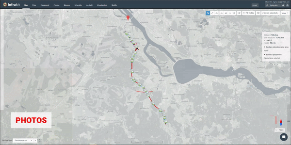
With the ability to have PDF documents, DXF/DWG and other design sources, orthophotos, and other base maps, you can work from a common source of truth all on a shared map.
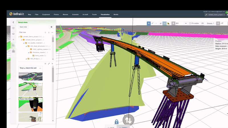
Tools, like Infrakit FIELD (mobile app), and Infrakit OFFICE combine to offer simple workflows to capture and tag photos for undocumented risks during site trips and help tender teams, who generally lack easy access to BIM tools, to visualize 3D elements in the office or the field.
Users can also capture dronemaps for work phase planning, taking advantage of different seasons for comprehensive ground condition assessments.
Book time with our experts to discover how these solutions can be leveraged for improved efficiency and success in winning your next construction tender!
Black week offering of Infrakit in terms of version 3.8.7!
Black Friday, nowadays seemingly more like a black week or two, is without a doubt the most notorious sales day of the year. There are pros and cons to it, but all in all, if you make smart purchase decisions during it, it will be very good time to buy Infrakit as a Christmas gift for your loved ones… Oh… no… I, I meant buying something nice can be smart… Though Infrakit is very nice, maybe I would not give it as a Christmas gift for children. 😀
Ookay jokes aside, our products are maybe not be the ones that are the hottest of the hot during Black Friday, but we still wanted to give you something a bit extra this time, in terms of developing more awesome stuff into our products! Let’s go check them out!
Capture your map beautifully!
How wonderful would it be if you could think of something, and Infrakit would do it as you wish?
Undoubtedly awesome, and even if that is not yet the case today, we took one step towards it by enabling you to select an aspect ratio and area with OFFICE for your Map image capture tool! We added also some options to modify the legend contents!
Let me teach how to do this via this video!
Powerful metadata in the palm of your hands
Knowledge is power they say. Clichés are clichés not because they are dumb but because they are too true too often.
We want to make you powerful by having all your knowledge of the project in the palm of your hands (especially, if you keep your laptop mouse in your palm). For this, we brought the plan features metadata visible to you, when you click the LandXML!
Watch the video to make this power yours!
Simple but fast… we upgraded your use of files and images into next level
Images and files… So simple things, but yet they can be such a burden so often when they become too many.
If we say knowledge is power, then we say speed is… well, speed. What is interesting in the case of using software like Infrakit, is that speed is not only made by how fast something works, but also how much there are roadblocks to take away your speed. Those roadblocks can be tiny but when you have plenty of them, they become a burden.
We took extra care as a Black Friday gift for you to remove as many small roadblocks of utilizing and viewing images and uploading files in Infrakit. For example image direction is visualized on map helping users to understand the insights from field in deeper depths!
As always it is impossible to tell you everything we did within one blog or you would have to read it as novel… so these are the highlights, but if you have interest on diving deeper to what new we have out there, check them from the Release notes in our Knowledgebase!
Hi Infrakit mobile app user, pay attention – Here is what you need to know about our new FIELD and SURVEY apps!
We have heard you. You have clearly not been satisfied with our Infrakit FIELD app, especially on Android devices. You as users and we as developers as well, want it to be a nice and smooth app, which helps you to do your work. (Note: These changes informed in this blog are only considering Android devices, if you are using iOS, you can skip reading this and continue your day!)
To make that smoothness and niceness possible, a while ago we made a decision to reconstruct the FIELD app completely, according to your needs. That process required us to acknowledge, that there is a strong differentiation within the user needs of the app. Some of you needed it for surveying purposes with integrations to GNSS equipment to take points, but some of you needed it rather for taking photos and managing project information.
We saw these different worlds in one app being an impossible combo to keep it simple and intuitive for all. It’s like having Food delivery and Social media platforms in one… Just too complex. Thus, we decided to take action, renew ourselves, and separate the app into two. From now on, there will be two apps, Infrakit FIELD, and Infrakit SURVEY. Now, I bet you are wondering “What are they then about, which one should I have?”. Do not worry, you have the right questions, and this blog can provide you with the right answers!
Infrakit FIELD vs. Infrakit SURVEY
After thinking about the difference for a while, it will seem obvious: Infrakit SURVEY focuses on surveying purposes and making it easy; Infrakit FIELD, on the other hand, focuses on being the project information management tool to be used in the field with your mobile phone.
The new Infrakit FIELD will be a completely redesigned version to be downloaded, whereas the Infrakit SURVEY will be staying as “the old Infrakit FIELD app” as long as we have gone through the rebuilding of it (yea, we are going to rebuild it as well!)
So, if you want to use GNSS devices to make log points transfer to Infrakit, Infrakit SURVEY is the one for you.
If you want to take photos, upload them to Infrakit with geolocation, visualize project information on the map such as models, or manage documents, the Infrakit FIELD app will be designed for you.
Now that the difference and what you have to do are elaborated, it is time to introduce the new Infrakit FIELD app core functionalities for you!
Infrakit FIELD -> Photo taking & management on site
Infrakit FIELD -> Visualize and check project information on FIELD
As mentioned earlier, the Infrakit SURVEY app will have the functionalities of the “old Infrakit FIELD app”, just under the new name, so we will not present them at this stage, but during 2024 when we aim to do the reconstruction!
For more app-using instructions, go check out our manuals from Knowledge Base!
Drag-and-drop orthos are here with Infrakit 3.8.6!
I bet hearing these stellar news will make even chief journalists of Times, Wired, and other of the world’s largest Magazines envy my position as a notorious Infrakit blog writer since I am the one that gets to first tell them… 😉
Okay, are you ready to hear it… Infrakit eats now orthos itself!
Now that it’s said and done, let’s take a bit deeper look into what this means for your work!
Stoop stop stop! I want to steal your attention still for a second before getting into the text -> Our Thesis worker Jetro has worked super hard for this feature to become captured reality (you see the pun intended 😉), thus, I would love to see you giving him a minute or two of your opinions regarding this feature. Link for a Master’s Thesis questionnaire at the bottom of the text, Let us help Jeti!!
Getting orthos into Infrakit has never been easier…
Would be cool to demonstrate my newly learned skills among orthophotos by explaining to you technical buzz-words to make you break a sweat «Oh this guy knows what he is doing». But honestly, the feature is so simple that a chimpanzee could use it, so I guess my days of acting cool are over… I mean basically, just by dropping the files into Infrakit you can get access to your orthos in Infrakit Map, Now think about that!
Let me rephrase this from your point of view. Your work life will get a ton easier by having the relevant and up-to-date information in the form of orthophotos readily chewed up on Infrakit because this feature lets the drone gurus do that so quickly!
Currently, supported file formats are .tif, .tiff, and .jp2, and all the necessary knowledge and information on using this feature can be found in our KnowledgeBase.
Check the easiness of this from this video!
… and they can be opened in third-party as well!
Until Matrix comes alive there is not a single system that can perform everything needed everywhere in one place. Not even Infrakit can solve everything on its own and we quite humbly recognize that. Thus, as always, we want to be as flexible as possible with other awesome software out there, making your life easier when jumping from one software to another!
For this, we pursue making the opening of uploaded orthophotos in third-party systems superbly smooth! Go check how this is done with Civil 3D from the video below, and other cases from our Knowledge Base!
And a special announcement for integrators and customers having their own pipelines for orthomosaic processing! Please contact us for guidance on super simple APIs that make sharing your content with Infrakit users a true delight.
Super Sharp DWGs!
You tell us and we hear you! DWGs are essential data to be visualized for you on the Infrakit platform and that is precisely why we have been going the extra mile to make them super sharp and functional for you.
Now we dare to say the version 3.8.6. starts to have them in a fashion that is ultra crisp and clear, take a look at yourself!
For all Autodesk users out there! Now you can also download as-built as a DXF file, data nicely organized to layers by codes.
Pssst… If you are a hardcore Infrakit user, here is a little easter egg for you -> go check what is new on the Infrakit Admin page… or rather, what has made its return 😉
Three awesome highlights of the Infrakit 3.8.5 version, that will make your day!
Aaand welcome to the notorious release blog session of the month once again my dear fellow user!
This is the place where we take our work uniforms off, grab a nice fresh ice cream cone from the close-up supermarket, and leave up the “strict” talk of business. Instead, let’s talk to fellow users, and enjoy the new features our superpowered R&D team has prepared for us!
Though jumping into highlights of “the new stuff” could be cool, let’s spend a second considering “How is the summer until now going on so smoothly and nicely…?”. Well, though the weather has been great “at least here”, it is not a coincidence that everything feels smooth because we have spent more time than ever on improving features by fixing bugs in there! And now let me guide you to the highlights!!!
Batch edit properties like a Flash!
Not sure if there are a lot of superhero movie fans out there, but if you have even crossed some ads promoting the movie “The Flash” you surely know that guy is fast!
And so is the editing of properties of photos! Instead of one by one opening the property and editing for photos, you can be the Flash of your organization to whom everyone asks, “How are you so fast with everything”. You don’t have to reveal your superpower of editing photo properties in batches or you can, either way, your speed will be undebatable!
Enrich your mass haul freight reports with photos
Remember when the e-scooter rental companies like Tier decided to add a photo-taking feature for showing how the e-scooter has been parked? For users that was kind of a small thing, though an easy one, but imagine how much help it provided for the ones who had to check how those e-scooters are parked? As an e-scooter company worker, your life just got so much better that day!
And we did something like that for you! The Infrakit TRUCK app is an awesome and simple approach to controlling mass hauls and freight reports on your site, and now when being able to take pictures of your scale receipts and other additional documents of the trips, it will become so much more useful! And boy are they useful for supervisor when reviewing the trips and freight reports from Infrakit OFFICE! This feature will be brought to you in TRUCK app 2.2.0 version, behold!
Check the way from the video below.
Drastically improved design data support
When using Infrakit as your Go-To tool for managing a project in construction, having all the design data nicely flowing in and getting visible correctly on the map is a day maker. It’s annoying and frustrating when a DWG file is missing objects, landXML Stringline models are messed up or the Tekla IFC models have their weird circus-like colors. Luckily, for this release, we got them in a much much better shape since we fixed over 30 issues on DWG, LandXML, and IFC parsing!
Also, checking the brand new IFC 2D presentation and support of IFC 4×3 will show how much the design data support has enhanced! And finally, measurements in the map can now be edited as well, which ought to make your life a ton easier!
With this video presenting all these awesome improvements, have a nice and awesome summer, hope you did not forget to eat your ice-cream you had alongside reading this 😀
Check the more in-depth list of new features and improvements of this version from our Knowledge Base
We use technologies like cookies to store and/or access device information. We do this to improve browsing experience and to show (non-) personalized ads. Consenting to these technologies will allow us to process data such as browsing behavior or unique IDs on this site. Not consenting or withdrawing consent, may adversely affect certain features and functions.
Functional
Always active
The technical storage or access is strictly necessary for the legitimate purpose of enabling the use of a specific service explicitly requested by the subscriber or user, or for the sole purpose of carrying out the transmission of a communication over an electronic communications network.
Preferences
The technical storage or access is necessary for the legitimate purpose of storing preferences that are not requested by the subscriber or user.
Statistics
The technical storage or access that is used exclusively for statistical purposes.The technical storage or access that is used exclusively for anonymous statistical purposes. Without a subpoena, voluntary compliance on the part of your Internet Service Provider, or additional records from a third party, information stored or retrieved for this purpose alone cannot usually be used to identify you.
Marketing
The technical storage or access is required to create user profiles to send advertising, or to track the user on a website or across several websites for similar marketing purposes.


Recent Comments