Consultant on quality assurance during the project on National road 4 between Kirri and Tikkakoski: the highway section was completed 8 months ahead of schedule and on budget
The highway section of National road 4 was completed eight months ahead of schedule and within the budget. Infrakit was used, for example, in site monitoring and quality assurance across the entire project organization. We asked Welado Oy’s Area Manager Arto Hyvärinen what using Infrakit in project management and real-time quality assurance was like from the point of view of the client and consultant.
Background information about the project
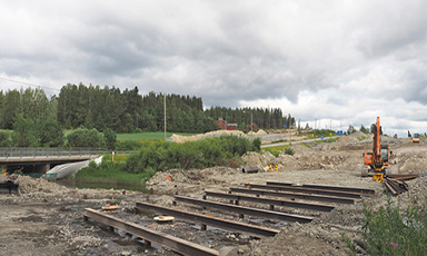
The project, which started in 2018 with a development stage, was scheduled to be completed by 2023, and it was commissioned by the Finnish Transport Infrastructure Agency. The project was for improving the condition of national road 4 between Kirri, Jyväskylä, and Vehniä, Laukaa. Between Kirri and River Makkarajoki, the highway runs in a new terrain corridor, and between River Makkarajoki and the Vehniä multilevel interchange, the highway runs in the existing terrain corridor.
Main road 4 is constructed as a 2+2 road with a median barrier. In addition to the highway, a parallel road is constructed for the entire section. (Destia.fi)
Main road 4 is part of the national TEN-T core network. The traffic volume on main road 4 at Kirri is about 20,000 vehicles a day, of which 10% is heavy traffic. Main road 4 is one of the most important routes for heavy traffic in Finland. (Väylä.fi)
Project goals:
• Improving traffic flow and road safety
• Providing better conditions for heavy traffic
• Improving the conditions for business activities in the area
• Creating better routes for walking and cycling
Welado Oy’s Area Manager Arto Hyvärinen participated in the project as a construction consultant and assisted the client in project supervision and safety coordination, among other things
The first time I used Infrakit was in a project conducted in 2013 and 2014 when I was working as a contractor for my previous employer. At that time, we participated in an ELY Centre project in Central Finland, which involved piloting Infrakit together with the client.
In 2018, I started working as a construction consultant for Welado Oy and subsequently in the Finnish Transport Infrastructure Agency’s group of infrastructure projects on traffic connections to Metsä Group’s bioproduct mill in Äänekoski with a total value of approximately 80 million euros. This group of projects was launched as early as 2016 with BIM-based design and construction. One of the contractors for the group of projects was Destia, which was using Infrakit. As the client, the Finnish Transport Infrastructure Agency also had credentials and access rights to the systems. That way I got involved in larger projects and using Infrakit’s system.
Role in the project
The development stage of the project on national road 4 between Kirri and Tikkakoski, implemented as an ECI project, ended in spring 2019, after which the construction work commenced.
I got involved in the implementation of the project as soon as the development stage ended. The Finnish Transport Infrastructure Agency put the related support tasks, supervision and safety coordination out to tender, and Welado Oy won the tender. Since then, I have been supporting the client in the supervision of matters related to the project’s implementation, quality and safety.
The design and implementation of the project is completely model based. Infrakit is one of the tools used in the project’s implementation. I used Infrakit, for example, for controlling the as-built data produced by the machine-control equipment and surveyors, which enabled me to monitor the project’s progress in more or less real time. It also enabled us to compare the as-built data with the designed surfaces and levels in accordance with the component-specific tolerances.
Features used
The ability to produce photographic documentation in the system is one of its key features. The progress of the construction was documented on a component-specific basis with the aid of photographs taken with mobile devices, for example. The contractor also had access to a drone whose 360 camera was used to document the progress of the work at regular time and pile intervals throughout the entire construction stage. This was a great help, as it enabled us to determine the needs of third parties in detail using almost real-time drone orthophotos and without having to leave the office.
The contractor also uploaded orthophotos to the system to serve as background map images and adding project maps over these images helped us verify that the roads, lines and structures had been implemented in the planned places. This also helped us monitor the project’s progress for the part of pavements, pavement markings as well as finishing and surface structures.
Moreover, in connection with realized structures, we were able to utilize the views using as-built data to show the locations, inclinations, tolerances and functionality of the drying, lighting and surface structures, for example.
Challenges and benefits
Typically, the implementation of a project like this entails, regardless of the size and content of the project, tackling challenges daily. Infrakit as a system and the degree of digitalization in the industry make the work easier, as we produce enormous amounts of data in real time during the construction.
It is easier to respond to changes and challenges and make decisions based on the data collected during construction when we have as much background information and facts as possible to support us in that endeavor. Thanks to all this, we can establish a snapshot of the situation, make decisions as well as take further measures and monitor them more quickly and easily.
“Infrakit definitely makes work more efficient, especially by providing access to real-time data regardless of your location. Thanks to all this, we can establish a snapshot of the situation, make decisions and take further measures more quickly and easily.”
For example, with real-time photographic documentation, you do not necessarily have to spend time on getting to the site but can check the situation from behind your desk or on a mobile device wherever you are.
The use of the mobile application also became familiar when moving about on site. When you are in a large project area, the mobile application helps you determine your location quickly and shows the route and the pile interval you are at. Combining data from Infrakit and other digital systems enabled me to show the progress of the work and facilitated reporting on it.