Navigating the Nuances Between Design BIM and Construction BIM in Infrastructure Projects
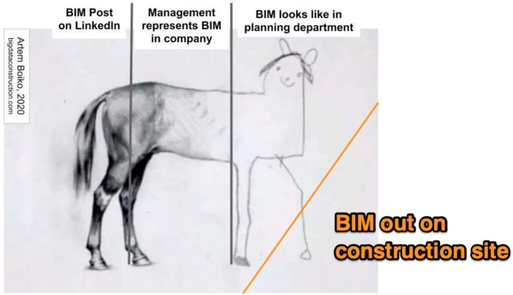
Shoutout and credit to @ArtemBoiko for the image above, with our creative addition.
Shoutout and credit to @ArtemBoiko for the image above, with our creative addition.
Navigating the Nuances Between Design BIM and Construction BIM in Infrastructure Projects
Building Information Modeling (BIM) stands as a foundational technology driving efficiency and precision. However, not all BIM is created equal. There are significant distinctions between Design BIM and Construction BIM that professionals in the field must understand to optimize their projects.
Design BIM
Design BIM primarily focuses on planning and architecture, creating detailed digital representations of buildings and infrastructure. Design Engineers use it to incorporate spatial relationships, geographic information, building component properties, and running excessive analysis, such as FEM. This model is useful for visualizing the final product, ensuring requirements and alignment, and seamless integration into the environment. However, transitioning this model to Construction BIM presents challenges.
Some owners still procure design work deliverable as a PDF drawing even though design process may be model-based, but it is increasingly common to have IFC (Industry Foundation Classes) models from the design process also to the site.
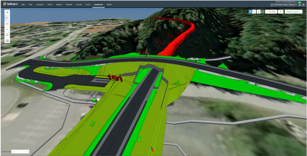
Credits: Sobstad AS, Tanem-Tulluan
Construction BIM
Construction BIM is practical and hands-on, adapting design models for construction needs by adding details like temporary roads. It must be compatible with on-site machinery. A key point of Open BIM and connected workflows is that a single exported model can be accessed by designers, owners and site people, but also sent directly to the construction equipment. Workflows typically include visualization, content and continuity analysis, volume calculation, precision machine control and stake-outs. Extra work and risky conversions should be avoided and performance and usability on site equipment should be ensured.
The LandXML format is synonymous with Earthworks and Road construction BIM in today’s workflows because of its suitability and support on various systems and construction software. IFC is a similar keyword for any structure such as a bridge or building.
When PDF files are received, Construction BIM models are typically rebuilt by the Chief Surveyor as an extra data preparation step to enable any sort of surveying on site.

Challenges and Industry Perceptions
While «build before you build» is a sound concept allowing significant simulation, BIM often falls short beyond this premise, raising the question: Has BIM failed?
Some argue the concept needs rethinking and restarting, focusing on construction rather than design needs. Until then, the industry will continue to be held back.
Project models may yet introduce challenges in the Construction BIM landscape too. Earthworks projects are full of surprises and rapid design changes are a must for successful projects. Thus, project models where the contractor does not have access to rapid digital design changes, leaves a ton of the available benefits behind.
Whatever the case, Design-build or Alliance project models where refined and approved models are available in a matter of days are generally seen as more successful compared to bid-build projects.
One challenge for the Construction phase is that the same model needs to run on AEC-grade desktop computers and all field instruments that have much lower processing capacity. So, despite its potential, IFC workflows for construction use still require more optimization and standardization.
Practical Recommendations
Owners should abandon a PDF approach and jump to procuring model-based construction; if it feels overwhelming to start with 2D drawings located in the project’s coordinates and scale, they can use DXF instead of DWG. Designers often prefer DWGs, but these are troublesome for neutral parties due to their proprietary binary format and complexity. DXF, by contrast, is open and easier for neutral parties to support.
This proprietary versus open format debate leads to General Contractors working with whatever Designers provide, often resulting in double payment for BIM designs that miss out on more real-life benefits. Many customers have experienced full BIM designs being discarded at the start of construction, highlighting the disconnect between design BIM and practical construction needs.
Any digital model or drawing is much better for the data prep step than PDF files, but the above points must be considered, and data needs to be converted and sanitized, typically to LandXML format for ultimate interoperability and to suit today’s site workflows.
Conclusions
The closest the industry has come to interoperability between all stakeholders in the model-based process is the Inframodel standard that introduces sufficient requirements for design and site workflows. Thus, for IFC to succeed, MVD (Model View Definition) for Construction workflows would be needed and internationally agreed as a standard so that all stakeholders and vendors on site would be able to use the same model efficiently.
In the meantime, Infrakit continues to provide a neutral platform for infrastructure projects, effectively managing the shift between Design BIM to field-ready Construction BIM. This can mean the difference between a project that is on time and under budget, and one that faces challenges in execution. Until the industry rethinks BIM from the ground up, focusing on practical construction needs and data flow, these challenges will persist. BIM has the potential to revolutionize construction, but only if it evolves to meet the practical realities of the field.
Book time with our experts to discover how these solutions can be leveraged for improved efficiency and success in your next construction project.

Recent Comments