Infrakit project Tampere light rail nearing completion – 26 million euros below original budget

Infrakit project Tampere light rail nearing completion – 26 million euros below original budget

The first phase of Tampere Tram project is now 90 percent complete and the savings are estimated to be up to 26 million euros. Over three and a half years, the tramway tracks have been built faster than planned. Construction for the first phase started in spring 2017 and traffic is set to start in 2021.

According to Sari Valjus, the project manager of the Tram Alliance, on Kauppalehti article 17/10/2020, the moment is historic as rail works – the most important work phase of the project’s first part, is now completed. Read the whole article on Kauppalehti in Finnish here.

Infrakit was used on the project. Check our reference article of the project here.

For more information, contact:
Teemu Kivimäki, CEO and Founder
teemu.kivimaki@infrakit.com
+358 50 344 6465

Linda Hakala
December 2, 2020

Book a Demo

Discover how Infrakit connects your entire infra project operations and drives value to every part of your business.

Compatibility and independence form the basis for success

Compatibility and independence form the basis for success

For many parties in the GWW, Infrakit has become a very important tool. But what exactly gives Infrakit the ‘X-factor’? We talked to Tiny Nuiten, Managing Director at Infrakit, to try to find out what exactly this X-factor is.

When we look at Infrakit, the first thing that stands out is it independence from brands and other platforms, Nuiten says. We’re not limited to one specific brand. Machine-controlled or a measuring app? Just connect it. That’s also true about other data, such as documents, reports and pictures: Infrakit is compatible with all kinds of data and accepts practically everything.

‘Stick to what you know’

At Infrakit, our principle is: ‘Stick to what you know’. Nuiten: “We don’t go on any experimental diversions. We deliberately choose to do what we do extremely well. What we lack in-house, we source from other specialists. It goes without saying that we go about this with care, we don’t contract just any company. After all, we want to be able to guarantee quality across the board.

Infrakit ensures that hardware manufacturers are able to work together. This also applies for other data processors, such as Microsoft, Viktor, Relatics or Autodesk. “So we’re always looking to connect with specialists that share a common ground with what we do and have a similar objective. We establish partnerships and our clients validate the entire process. Our major clients are constantly working on the digitization process and looking for ‘the right tools for the right job’. One of those tools is Infrakit. We connect all the other tools they use and therefore play a pivotal role in the digitization process”. Nuiten refers to Relatics as a case in point: “Our customers use it and want to test information, that’s the reason for integrating with Relatics.”

Infrakit is a “gateway” in and out of BIM.

Independence as a priority

Infrakit believes that its independence is paramount. “We can’t just opt for one connection. We want to work on an open basis. Infrakit has become a central access point for Building Information Data. Whether it’s about that one particular model, drawing, picture or document, Infrakit allows you to centralize things at the front of the chain and make it available to everyone”.

In our experience, once you start digitizing, you quickly get a taste for it. Nuiten agrees with that. “Yes, digitizing makes you want more. It starts with one thing and then the wish list quickly expands. The great thing about Infrakit is that it’s prepared for this expansion. Infrakit is your guide that will take you through all stages of the process. That’s business optimization at its best. Everyone can contribute and share their information with all those involved.

Also for project owners and commissioning parties

An additional, not insignificant factor, is the fact that project owners and commissioners are becoming increasingly interested in Infrakit. “That makes sense, because it allows you to monitor the process, confident that everything is always in real time and up to date. Some government agencies even include Infrakit in their specifications. Did you know that Infrakit is a perfect tool for managing the entire tendering process? By continuously working with Infrakit from the moment the tender is placed, you’ll be able to use Infrakit during the maintenance stage. So from preparation, execution, and delivery to maintenance you’ll have all your data centralized and up to date.

Easy access to BIM

Infrakit is a so-called ‘Single Point of Truth’. “A central point for accessing real-time data. Once something is in Infrakit, it will speak the same language across the board, making Infrakit a gateway in and out of BIM. It doesn’t get any easier than that to access data in BIM. “Finally, another good example. Through recent experience, our clients have found out that by using Infrakit on an overall basis, it’s possible to achieve savings ranging from 10 to 20% of the project budget. This is not an estimate, but actual experience. That’s when you understand how important Infrakit can be.”

‘We are not limited to one specific brand’.

Infrakit is compatible with all forms of data.

Tiny Nuiten
November 26, 2020

Book a Demo

Discover how Infrakit connects your entire infra project operations and drives value to every part of your business.

Infrakit: the data-sharing solution that revolutionizes infrastructure construction sites

Infrakit: the data-sharing solution that revolutionizes infrastructure construction sites

Infrakit: a high-performance data-sharing solution at the Paris Line 11 site

Regarding the extension project for metro line 11 in Paris, Anthony Balbeurre, foreman at Bouygues Construction, is able to rely on a new tool to collect and share data in real time: Infrakit. Developed in Finland (where it is used on most infrastructure construction sites), Infrakit makes it possible to collect data on-site and exchange all data necessary for the project to run smoothly.

A shared data management solution

Infrakit’s promise is simple: to allow everyone involved at a construction site to easily exchange, in real time, all data necessary for the design, progress and successful delivery of the project. Infrakit relies on several key principles: format interoperability and cloud storage. With its powerful, universal online plan and data viewer, Infrakit makes fully digitalized site management possible, both intuitively and quickly.

In practical terms, Infrakit can be installed on many devices (tablets, mobile phones, laptops or desktop computers) and allows all stakeholders at a site to enter data (aerial or land photos, topographical surveys, proofing data, figures, notes , plans, etc.) on the project documentation. Once entered, the data is shared in real time with all stakeholders, via cloud storage. In terms of compatibility, Infrakit can be used with all the main hardware and software solutions in the industry: Bentley, Autodesk, Trimble, Novatron, Leica, Topcon, and many other CAD or site tracking software.

An appropriate tool for all phases of the project

One of Infrakit’s strengths is that it can be used from the design phase of the project until its final delivery. During the design and preparation phase, Infrakit brings together 3D plans and models from all the draft designers in the same place, so that they can be viewed, combined and checked for possible errors before arriving on site.

During the construction phase, at the Line 11 site, Anthony Balbeurre was able to use Infrakit in combination with a surveying antenna (equipped with an on-board GPS), which allowed him to measure extremely precisely (2 cm accuracy) the work carried out by the machines in the field. Thanks to this centimeter-level precision, he was able to carry out inspections on the work as he progressed, after completing the earthwork or pouring concrete, without having to bring a surveyor/topographer to the site.

Having this GNSS antenna (a Septentrio Altus NR-3 in this case, but Infrakit also works with other brands) and Infrakit makes it possible for these reception and control surveys to be performed as the work progresses independently. Once these readings are validated to match the design outlines, the work can continue without delay. Before using Infrakit, the foreman had to complete these surveys using another (unconnected) device and then, at the end of the day, take the time to extract the collected data and pass it on to other stakeholders like the head surveyor. Thanks to the interoperability of the GNSS antenna that they use now, in combination with Infrakit, the transmission of the data happens simultaneously with their input.

Infrakit thereby offers significant on-site time savings, even if the acceptance phase (which is an inevitable contractual validation) must still be carried out by a surveyor, who operates with his/her own tools (but, who nevertheless uses Infrakit to update his/her data with the rest of the teams).

Crucial assistance for site managers

Anthony Balbeurre, in charge of earthwork for the extension of metro line 11 clearly explains, “Infrakit helps me get all of the coordinates and designs in real time at my site and, most importantly, I can react immediately, without having to bring a surveyor out to the field. At the beginning of earthwork, I use Infrakit to locate my dirt entrances, as well as my ridges and embankments. During earthworks, Infrakit allows me to know exactly where I am, for example as it relates to altimetry. I can verify that we are in the right place and that we have not ‘eaten up’ the slopes too much, or, to the contrary, left too much material on them.”

For Anthony Balbeurre, being able to do without the daily visit of a surveyor, thanks to Infrakit, is an invaluable time-saver. He explains further, “I don’t have to bring the surveyor in all the way or wait for his information to move forward. For example, if I want to implant a sole (concrete bridge foot), thanks to Infrakit, the surveyor can communicate the file directly to me and, in just a few minutes, I get the information and I can go out into the field with my own GNSS antenna.”

Saving time, making work easier, fluid communication and real-time sharing of large amounts of data in a completely interoperable way: it’s no surprise that Anthony Balbeurre concludes by explaining that he recommends Infrakit, which he will use again in future projects.

Sebastien Cailliau
November 25, 2020

Book a Demo

Discover how Infrakit connects your entire infra project operations and drives value to every part of your business.

Building information models improve quality of construction

Building information models improve quality of construction

In infrastructure construction, information is increasingly being presented in the form of building information models (BIMs) rather than paper drawings. NRC Group uses BIMs in a variety of construction projects, significantly improving quality and productivity.

What is BIM?

Building Information Modelling or Building Information Models are known as ‘BIMs’ for short. In the infrastructure sector in general, BIM refers to a process spanning the lifecycle of infrastructure, and to management of the resulting information in digital format. BIM is also a way of working that emphasizes centralized information management, collaboration between actors, and visual modelling.

In practice, this can be seen in the increasing numbers of Finnish Transport Infrastructure Agency projects being completed — from planning to implementation — on the basis of BIMs. A good example of such a project is the improvement of the Pasila–Riihimäki track, in which the customer has reported savings of up to millions of euros with the help of BIMs: building information modelling provides a more accurate picture of what is being done and enables smart planning of work phases between multiple actors.

“Different programs can be used to visualize and analyze plans presented as building information models. Such models provide key information that can be used in the planning, implementation and reporting of a construction project,” says Jussi Heikkilä, BIM Production Manager. Heikkilä is responsible for the development and implementation of BIM-based construction at NRC Group Finland.

The right things in the right place at the right time

“BIMs provide a more detailed picture and calculations during the bidding and planning phases. With a mobile device, BIMs and other digital material can also be used during familiarization with sites in the field,” Heikkilä explains.

During the implementation phase, BIMs are primarily used for machine control (a feature of BIM-based construction) when creating earthworks. NRC uses this approach for all major projects. With the Infrakit tool, supervisors can monitor in real time what machine-controlled machinery is doing, and supervise the quality of work in relation to the plans. If the plans change, the machinery can be quickly updated accordingly. A faster response reduces construction delays and improves resource allocation: machinery utilization rates have increased as a result of BIM-based construction.

In fact, BIM has clear connections with the lean philosophy and goal of continuous improvement.

“BIM enables the realization of lean principles and continuous improvement in practice. It eliminates delays, waiting time and waste. It also makes work safer and more meaningful, as building information models provide better and more accurate plans for construction work. This means fewer surprises and conflicts between plans, and the implementation of projects as intended. So the right things are done in the right place at the right time.”

Effective information management

Building information models have been used in a number of ways at NRC Group, for example in the Mansikkakoski bridge project in Imatra, involving the construction of a new railway bridge over the Vuoksi river. BIMs have been used to check space reservations and ensure that a new bridge can be built across the Vuoksi as proposed by the designer. A combined model was used to ensure that the structures are compatible, and for clash detection.

“The overall project is much easier to visualize with a combined model, which facilitates the planning of work,” says Tiina Frilander, BIM Operator.

Picture: Finnish Transport Infrastructure Agency’s Mansikkakoski project/combined model of building plan
BIMs have also been used from the very start of the Kototolahti yard track extension project. Almost all construction — from cable routes to implementation of the track ballast layer — has been carried out on the basis of machine control models.

“Even during installation of track markings, done as additional work during the contract, we used machine control and the Infrakit application as a tool to ensure successful and precise installation,” says Samu Simonen, Project Manager.

Infrakit is the main tool used for BIM-based construction in both the Kotolahti and Mansikkakoski projects.

“BIM material and other construction data with coordinate information were exported to the Infrakit system during the Mansikkakoski project. Machine-controlled machinery, into which the BIM and construction material were wirelessly installed, was also connected to the system,” Frilander explains.

Information management is markedly eased by Infrakit, which enables the import of various documents and plans into the same tool. For example, Infrakit can be used to connect terrain photographs directly to the correct locations, easing overall project management. 360-degree panoramas and aerial photographs taken with drones were introduced last year. Drone images have been taken at different stages of the Kotolahti and Mansikkakoski projects, enabling easy monitoring and reporting of progress.

“Imaging material has also been used for the planning of work stages. The situation on the ground can be perceived in much more detail from a bird’s eye view,” says Simonen.

A drone orthophoto of the Mansikkakoski project

BIM-based construction has increasingly been used in non-construction work where, instead of three-dimensional BIMs, the most usable options are point cloud data concerning objects to be built or installed, or location-based digital project maps. In electrical construction projects, both supervisors and installation engineers use the Infrakit application, in which location-based project maps created using different technologies help supervisors to understand what is being built and ensure the feasibility of plans. At best, on a construction site installation engineers can use a mobile device with a separate GNSS receiver to view equipment installation locations with centimeter precision, without marking or measuring the terrain. The locations of installed structures can be documented immediately to enable the monitoring of progress and for the handover material.

Support for quality assurance

Continuous documentation of the progress of projects is also useful after their completion, since handover material is increasingly being provided to customers in digital format. Handover material is used to verify the quality of construction. Digital material is also easier to transfer to different systems, where information needed for care and maintenance needs in relation to construction projects can be found and used years later.

“The imagination is the only limit to the possible applications of BIM. Information management is the core around which everything else forms,” sums up Heikkilä.

This article was originally published on NRC group’s website in Finnish. View the original article here.

Linda Hakala
November 10, 2020

Book a Demo

Discover how Infrakit connects your entire infra project operations and drives value to every part of your business.

The Hämeentie Street Renovation – Towards Model-Based Production in Cities

The Hämeentie Street Renovation – Towards Model-Based Production in Cities

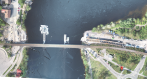
In spring 2019, the largest street renovation in Helsinki’s history began on Hämeentie. In addition to surface structures, the renovation project include water pipes, tram rails, cables and sewers. Protective structures beneath street level, in the roofing of the Sörnäinen metro station, have also been renovated. In the future, there will no longer be passenger vehicle through-traffic on the street, which is now intended for public transport, cyclists and pedestrians. Of course, driving into building yards will still be permitted. The urban environment, pipelines dating back to the early 20th century, and pedestrian and other traffic posed challenges of their own for the project.

Hämeentie is being renovated and built by Destia. We discussed the project and, more broadly, the gradual shift of street projects towards model-based production with Destia’s Development Manager, Mika Jaakkola, Hämeentie Project Chief Surveyor, Tatu Kallas, and Destia Automation Operator, Mikko Kansikas.

Hämeentie as a development project

The renovation on Hämeentie is now in its final stages. Chief Surveyor Kallas describes the progress made as follows:

“The end is already in sight. Around 99% of the tramway is ready. But there is still quite a bit to do in surface structures, for example.”

For Destia, the renovation of Hämeentie is its largest street construction project to date. In addition, more lessons have been learned about using model-based production.

For Destia, the renovation of Hämeentie is its largest street construction project to date. In addition, more lessons have been learned about using model-based production.

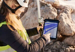
Model-based production refers to a new method and form of data transfer in infrastructure construction, in which construction-related plans are digitally available to everyone. Another key element of model-based production is the existence, in digital form, of construction process data and, for example, as-built models. Together, these allow for a comprehensive situational picture of the project. Infrakit is a project management system used in model-based production.

“The Hämeentie renovation has been a learning and development project in terms of model-based production. After all, the project planning was not model-based. However, we have studied how to introduce proven, functional practices, such as machine control and total station positioning, for roads in street construction. In addition, drone imaging and modelling are part of everyday life in the Hämeentie renovation project,” Jaakkola explains.

Urban construction differs from road construction

In comparison to roadway maintenance and construction, a great deal of attention must be paid to various traffic-related issues during urban construction.

“Traffic is a major factor, of course. During construction, we have to take people and traffic into account at all times. Then there is the existing infrastructure underground, including pipes and concrete structures,” Kallas explains.

“Yes, they are the man-made things of the past that bring some very surprising twists and turns to today’s construction work. The difficulty is hugely increased by the fact that people started burying things underground in the early 20th century,” Kansikas adds.

However, not all findings are documented, as this would take up a lot of resources and time.

“Of course, we document all the structures that we handle. We also have a development project on a portion of one street, where we have surveyed and modelled all underground structures,” Kansikas describes.

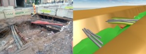
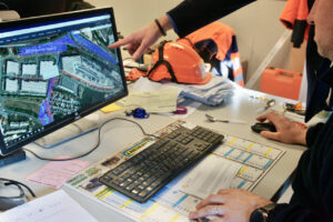
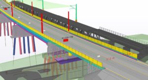
Existing cables on the street measured and exported to the Infrakit combination model. Photo: Mikko Kansikas, Destia Oy.
Challenges and solutions for model-based production in an urban environment


Model-based production requires different skills to those deployed in traditional construction methods, and is still not used in all new projects. Plenty of plans are still prepared on paper. However, the model-based method enables 3D visualisation of the future structure, making it much easier to grasp the overall building. Planners also take centre stage in this new way of working.

“Model-based construction is not yet widely used, and we still have a lot to learn in this area, in order to build efficiently,” Kallas explains.

“Alliance projects also extensively allow for advance planning, data mapping, data transfer and cooperation. There is a lot of good in that,” Kansikas says.

“Construction sites often grind to a halt if you can’t get a fast answer to something. The alliance model is one solution to this challenge. During cooperation, the initial data can be mapped more comprehensively, enabling higher-quality model-based planning and production. For example, we are involved in the Kalasatama-to-Pasila project, which is based on an alliance model,” Jaakkola says.

Using digital information in traditional construction processes

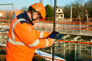
Destia used Infrakit for data management in the Hämeentie project.

“Infrakit is a great platform to which items such as background maps, plans and drone images can be added,” Kansikas explains.

“Infrakit is a great platform to which items such as background maps, plans and drone images can be added.” – Mikko Kansikas

“Images are used a great deal in construction and are very useful. However, drone images are better than traditional photos, as they are more informative. One person may take around 5,000 photographs over the course of 18 months on a project, which is several hundred per month. When you use a drone to take, say, orthophotos or aerial photographs over a kilometre of terrain every two weeks, you learn a great deal about the overall development of the site,” Kallas says.

“By utilising Infrakit, plans and models can be made available to the entire project organisation, from project management to builders installing piping. Fewer mistakes are made when those involved in a project have up-to-date plans at their fingertips. Furthermore, digital information can be used in traffic management and project management in general,” Jaakkola adds.

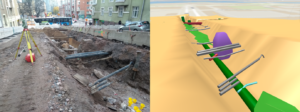
The planned new pipeline will collide with existing infrastructure. Infrakit makes it easy to adjust the plan before implementation. Photo: Mikko Kansikas, Destia Oy.


Fostering closer cooperation in data management

Further development is currently required in data management and the sharing of information between design and construction. Many individual details and measured lines and points are still being sent between project actors.

“If there were model-based plans, we could build more rationally. There are no problems with the machines themselves, the models can be transferred to excavators,” Kallas explains.

“There is still a need for development on the street construction side in this respect,” Jaakkola adds.

“At Infrakit, the information is readily available. There are also plenty of opportunities that can be exploited when building with model-based design. We know what to do,” Kallas says.

“Information travels faster between actors,” Kallas sums up.

It is easy to see the overall benefits of a real-time cooperation model and platform for planning and implementation in roadway and street maintenance. Infrakit’s visual nature makes it easier to solve problems: it provides the same view on home-office displays as would be possible on-site.

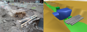
Adapting the new to the old virtually with a browser. Photo: Mikko Kansikas, Destia Oy.
Model-based production renews infrastructure construction


Finland and the Nordic countries have made huge strides forward in model-based construction.

“We have come quite far in this, especially in Finland and the Nordic countries. Model-based production makes a number of things possible; construction will be of higher quality, less expensive and more sensible,” Jaakkola describes.

“Our work will be more efficient and we will have a much clearer overall picture of projects,” Kallas adds.

“I would add that operating through a model-based method allows us to plan work more efficiently and reduce emissions,” Jaakkola says.

“I would add that operating through a model-based method allows us to plan work more efficiently and reduce emissions.” – Mika Jaakkola

“Although the Hämeentie renovation project was not totally model-based, much has been learned along the way, and we have become more familiar with Infrakit. We have tried to gather best practices from model-based production for this project as well. Infrakit has also developed new tools for us, which we have been able to use. In general, I would say that we just have to take the decision to work with model-based planning in various projects. It’s easy to move forward when developers complete a smooth pilot and have good experiences,” Kallas says.

“Although the Hämeentie renovation project was not totally model-based, much has been learned along the way, and we have become more familiar with Infrakit. We have tried to gather best practices from model-based production for this project as well.” – Tatu Kallas

“The same initial challenges were faced in road construction, but this area has moved further forward and new practices have been learned. People are often wary of new things and it can feel difficult to discard what has worked before,” Jaakkola adds.

“Growing pains will be unavoidable for a while, but I think that everyone should use the same model to avoid the fragmentation of work and knowledge,” Kallas says.

“In addition, we already have work to do and the required know-how, and are able to use model-based planning – it’s not a problem,” Jaakkola says.

“To sum up, we have found that model-based production works at Destia, and it’s a big deal that we can also use it for urban construction in the future. Planning still plays a central role and new methods can speed up turnaround times and reduce costs,” Jaakkola summarises.

Annika Helisvaara
October 14, 2020

Book a Demo

Discover how Infrakit connects your entire infra project operations and drives value to every part of your business.