Surveying and as-built data for infrastructure projects
GNSS surveying, real-time as-built data, and tolerance verification that catches deviations while correction is still cheap — not after the covering layer is already down.
Request a demo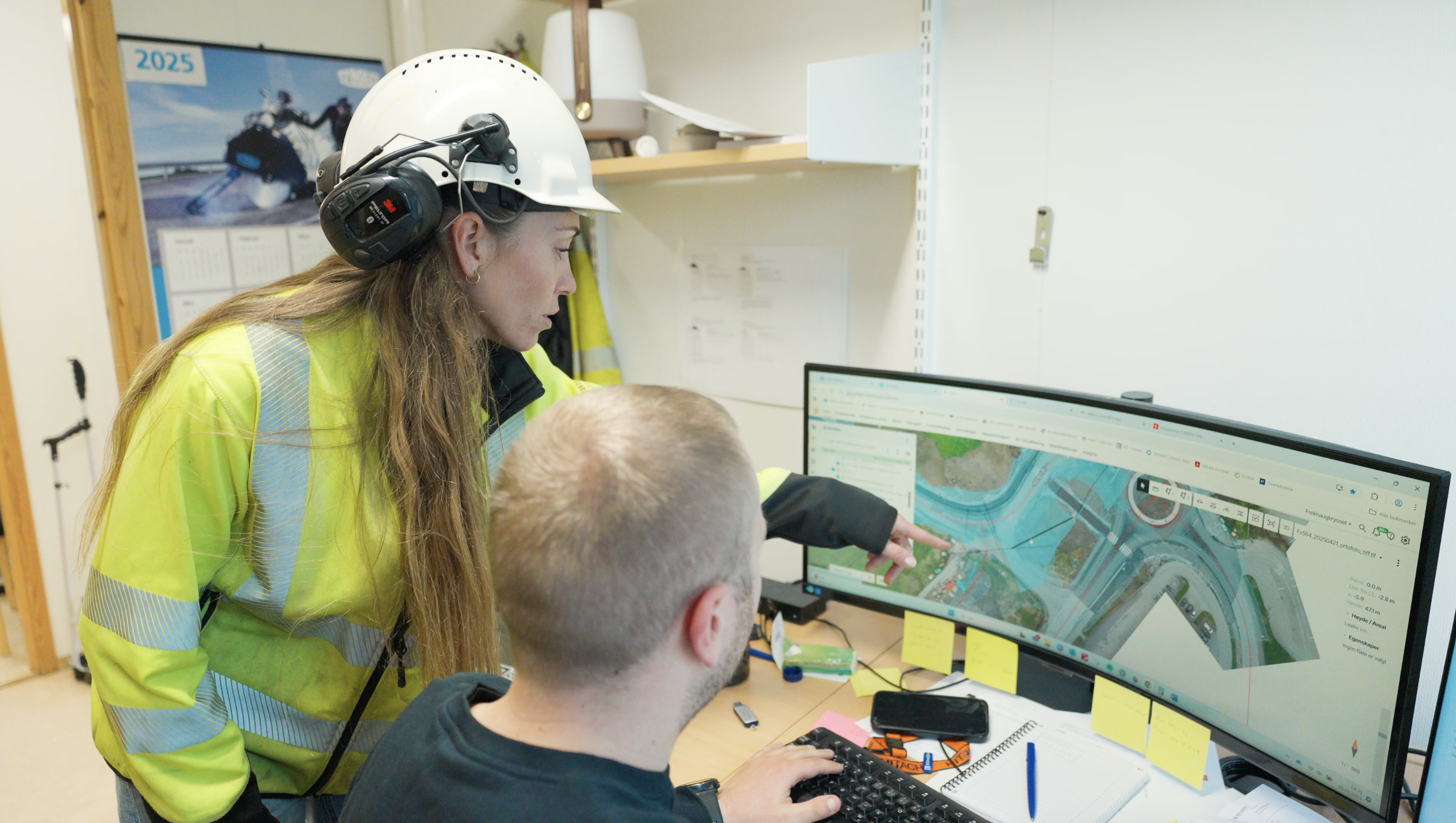
How construction surveying changes when GNSS data and as-built records flow to everyone on the project in real time — not just the surveyor. Case studies from Norway, the Netherlands, Sweden, and Finland on tolerance verification, as-built documentation, and traceability.
In infrastructure construction, surveying has always been the backbone of quality. Before a single cubic metre of earth is moved, someone has to establish exactly where things need to go. And once the work is done, someone has to prove that things went exactly where they were supposed to.
For most of the industry's history, that meant wooden stakes, tape measures, paper drawings, and a lot of walking. It meant surveyors spending hours on site just to answer questions that could have been resolved in minutes. It meant as-built data sitting in spreadsheets and folders, disconnected from the plans it was meant to verify.
That picture is changing — and the shift is more significant than most people outside the profession realise. Today, GNSS-equipped devices, cloud platforms, drone surveys, and machine-integrated workflows are turning construction surveying into something fundamentally different: a continuous, digital, organisation-wide function that supports every phase of a project, not just the moments when a surveyor happens to be on site.
This article looks at how that shift is playing out in practice, drawing on experiences from construction teams in Norway, the Netherlands, Sweden, and Finland.
Why traditional surveying created bottlenecks
The problem with the old model was not that it was inaccurate — skilled surveyors are extremely precise. The problem was that accuracy was locked inside one person's equipment and knowledge, and everyone else had to wait for it.
Site managers needed to know whether a trench was at the right depth before pouring concrete. Foremen needed to confirm that a slope matched the design before the next layer went down. Project owners needed documentation that work had been completed within tolerance — documentation that, under the old system, had to be compiled manually, often weeks after the fact.
Every one of those needs created a dependency on the surveyor. And on large projects — a 12-kilometre railway, a 32-kilometre motorway, a 6-kilometre road through varied terrain — that dependency became a serious operational problem.
Ole Jonny Ovenstad, site manager at Marthinsen & Duvholt, describes working on UNB01, a railway project spanning 12 kilometres, with 21 excavators running simultaneously that he was largely managing with just a couple of field staff. The old way of working — where the surveyor is the hub and everyone else waits — simply could not scale to that environment.
When surveying data stays locked in one person's workflow, the rest of the project slows down. See how construction field reporting and photo documentation solves a parallel problem — making site records accessible to everyone instead of buried in personal devices and email threads.
GNSS surveying: shared accuracy across the team
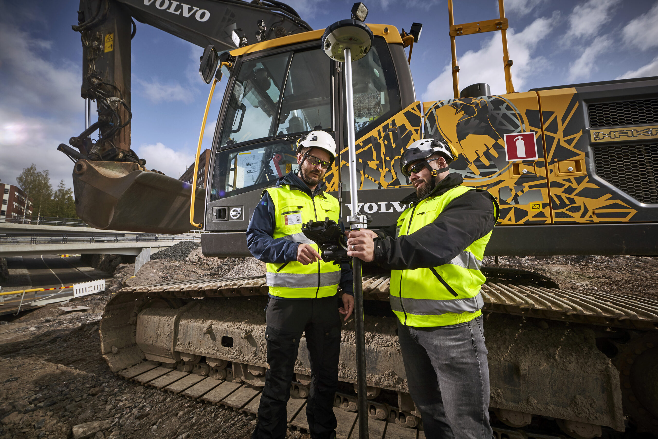
One of the most consequential shifts in modern construction surveying is the democratisation of GNSS. High-accuracy GNSS receivers, once the exclusive domain of licensed surveyors, are now being used by site engineers, foremen, and even machine operators to perform measurements that previously required specialist attendance. The implications are significant. When GNSS data feeds directly into a cloud platform, as-built points become visible to everyone with access — in real time, on a map, without anyone having to compile or transmit anything.
In Hoofddorp, Dura Vermeer used a marXact UNI-GR1 GNSS rover integrated with Infrakit to survey a residential repaving project digitally — "so that we know exactly what we are working with," as Carlo Eppink, Performer 3 at Dura Vermeer, puts it. The team measured existing pavement conditions and building specifications at centimetre accuracy, giving project leaders, subcontractors, and the client (the Municipality of Haarlemmermeer) a detailed, shared overview of quantities and locations.
Before this approach, site marking was done with paint lines on tyres — lines that faded in rain and wind, gave no precision, and left no retrievable record. "It used to be a line on the tire that could fade due to rain or wind, now our points are digital and even centimetre accurate." — Carlo Eppink, Performer 3, Dura Vermeer.
Crucially, the surveying function was not centralised in one specialist. Eppink himself regularly goes out with the surveying pole. So does the area assistant, who also handles communication with residents. By distributing the capability rather than concentrating it, the team reduced the surveyor's workload and gave execution teams immediate access to their own progress data. The result: project leaders could see progress in real time from their screens. Quality issues could be flagged before they became costly rework. And the data accumulated as a permanent, retrievable record — proving its value months later when the second phase began and teams needed to reference what had been measured in the first.
"Compared to walking the line with PDF drawings, pointing and sketching to explain what needs to be done — this was a night-and-day difference."
Ole Jonny Ovenstad Site Manager · Marthinsen & Duvholt, UNB01 Railway (12km, 21 excavators)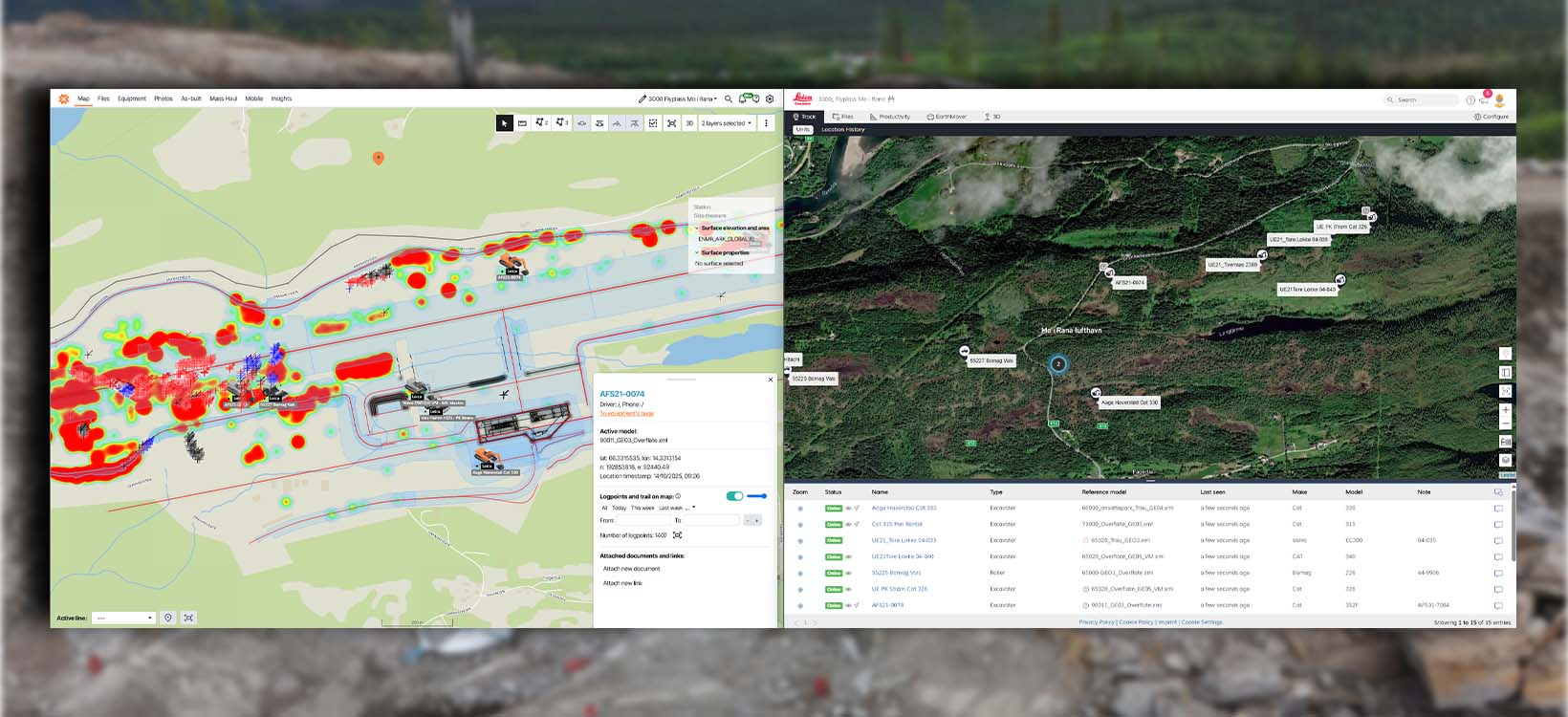
As-built documentation in real time
The most valuable as-built record is one that's created during construction — not compiled after the covering layer is already down.
As-built documentation — the record of what was actually built, versus what was designed — has traditionally been one of the most labour-intensive parts of a construction project. Surveyors would compile point data, site engineers would check it against drawings, and quality reports would be produced and filed, often well after the relevant work had been completed.
The problem with this model is timing. By the time a tolerance exceedance is identified, the structure may already be buried, backfilled, or built upon. Correction becomes exponentially more expensive. And the documentation produced after the fact serves primarily as a record of what happened — not as a tool for preventing problems.
The shift to real-time as-built data changes this entirely. When machine-measured points flow directly from equipment into a shared platform, the as-built record is created simultaneously with the work — immediately available to everyone who needs to act on it. This is particularly critical for infrastructure, where buried work — drainage, utilities, base layers — can't be dug up to verify. As-built documentation created during installation is your only proof of what's underneath.
Sundström, Finland: Weekly quality control directly in Infrakit
On the main road 8 project between Vassor and Ölis, Sundström used Infrakit as the single platform for all as-built measurements across a 5.4km road reconstruction — completely rebuilt, widened, re-levelled, with new intersections, lighting, noise barriers, and an animal crossing tunnel. All data from machinery transferred directly into Infrakit, where both the client and contractor could check quality and monitor progress in real time.
Sanna Kara, responsible for land surveying at Sundström, describes the workflow: design documentation was submitted directly to the contractor via Infrakit at the outset. Machinery quality control — including weekly monitoring of as-built dimensions — was then carried out continuously throughout the project using the platform as the reference environment.
The outcome was not just better documentation. It was a fundamentally different working relationship with the client. Rather than receiving periodic reports, the client had live access to the same data the contractor was using to manage quality. Transparency replaced the traditional information asymmetry between owner and builder. The project was completed nearly 12 months ahead of schedule — and the availability of shared, real-time data was central to that outcome.
Real-time as-built data across your whole project team
GNSS rovers, machine control systems, and drone surveys all feeding one shared platform. Tolerance issues caught during construction. As-built records complete and retrievable from day one.
"Infrakit has provided us with a common platform that has helped the installation engineers, machine operators, supervisors, persons in charge of land surveying as well as the client's representatives stay updated on the designs and project progress."
Sanna Kara Land Surveying · Sundström, Road 8 (Vassor–Ölis, 5.4km)Tolerance verification before it gets expensive
Tolerance verification — confirming that constructed elements fall within the acceptable deviation range defined in specifications — is where the gap between traditional and digital surveying is most visible in terms of cost impact.
In traditional practice, tolerance exceedances are often discovered late. A layer is built to the wrong thickness. A pipe is laid at the wrong depth. The deviation is only apparent when the next survey batch is processed — sometimes days later. By then, the covering layer is down and the correction requires excavation.
Real-time as-built data eliminates this delay. When machine operators and site staff can see their own as-built points overlaid on the design model continuously, deviations are visible as they occur — not after.
Risa AS, Norway: Mobile GNSS replacing physical inspection
Risa AS, one of Norway's largest construction contractors, has been using Infrakit for four years across a range of transport, wind energy, and maintenance projects. Ellen Størkersen, BIM Coordinator at Risa, and Jarle Vatne, a project manager, describe a specific change in how tolerance verification works on their sites.
Previously, checking whether the correct model was in use at a given time — and whether work was being executed within tolerance — required physical presence. Someone had to go to the machine, inspect what was loaded, and visually assess the work against drawings. Now, that process has moved to a mobile phone.
Georeferenced photographs add another layer to this. Rather than guessing where a photo was taken from a library of hundreds, images are automatically tagged with their location and linked to the specific part of the project map they document. When quality questions arise later — during warranty periods, disputes, or handover reviews — the photographic record is immediately retrievable by location, date, and responsible party.
The broader benefit that Risa identifies is not just individual time savings, but systemic quality improvement. When it is easier to verify tolerance continuously, deviations are caught earlier, margins of error are smaller, and the cost of correction is dramatically lower.
When tolerance verification connects to BIM coordination, teams can compare as-built survey data against design models across all disciplines. Learn how BIM for infrastructure projects closes the loop between design intent and field reality →
"You do not have to jump into a machine or bring out GPS. Instead, you can use your mobile phone and get an overview of where you are and what is to be built. When quality improves, there are fewer sources of error and margins of error, and errors are easy to spot."
Ellen Størkersen BIM Coordinator · Risa ASDownload: 10 Steps to Deliver Infrastructure Projects On Time & On Budget
Learn from teams on the Tampere tram, Norway's E6 highway, and Austria's A9 motorway — including how they use shared surveying data, real-time as-built documentation, and integrated quality workflows.
Drone surveys and site documentation
A recurring element across modern digital surveying workflows is the integration of drone photogrammetry. Regular drone surveys — typically weekly or monthly — provide an orthophoto baseline that ties together all other data layers: machine as-built points, design models, photos, and notes all appear in the context of a current aerial view of the site.
This matters for tolerance verification because it enables progress to be assessed visually, not just numerically. Volumetric calculations can be run from drone data. The spatial relationship between completed and planned work is immediately apparent. And the time-stamped nature of each flight creates an automatically generated project history. For a deeper look, see our complete guide to drone mapping for construction →
Trigo Mätteknik, Sweden: Traceability as a core project outcome
Trigo Mätteknik, a Swedish surveying specialist that supports major civil and infrastructure projects, has built drone surveying into the core rhythm of their project work. Richard Åberg, Survey Engineer at Trigo, and Johan Mattsson, Business Area Manager, describe the combination of Infrakit and Topcon Sitelink3D as solving two distinct problems simultaneously: shared access to the latest information for all stakeholders, and a reliable office-to-machine data flow for machine control.
The self-service access model that Infrakit enables — where any stakeholder can find the latest design data, photo, or as-built point without routing a request through the surveying team — is described as the primary operational benefit. On sites with dozens of machines running in parallel, that reduction in interruptions directly translates into surveyor productivity.
But Trigo places equal emphasis on traceability. In fast-moving projects, questions arise after the fact — about what condition a site was in before excavation, which version of a design was active when a particular element was constructed, or whether a reported defect existed before or after a contractor's work.
The ability to revisit any moment in the project's documented history, by navigating a time-based archive of georeferenced photographs and drone imagery, helps teams resolve disputes quickly and support discussions with evidence rather than assumptions.
"You can go back from the start of the project and see — this day, this part of the project was built. Just click your way back, you will see what happened last week, and the week before. It's beautiful in that sense."
Johan Mattsson Business Area Manager · Trigo Mätteknik / Salboheds (up to 90 machines on one site)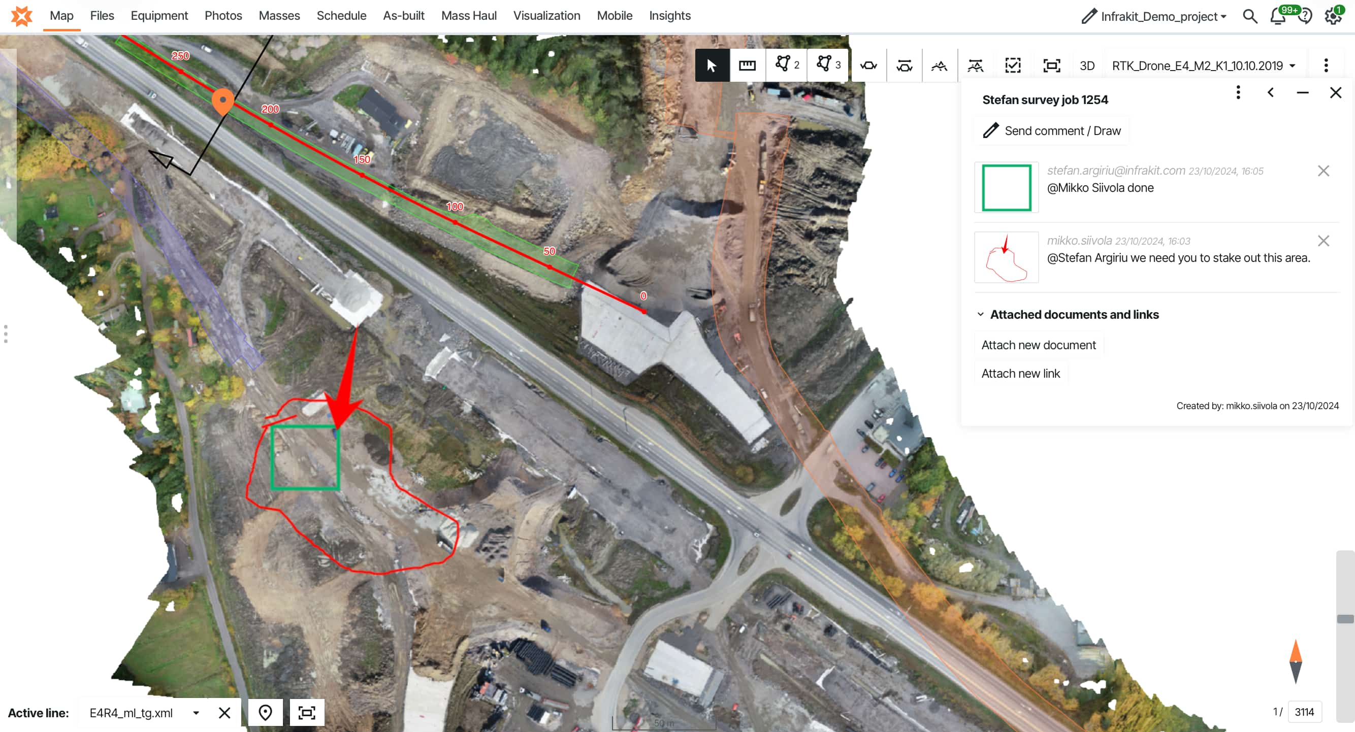
The common thread running through these case studies is a shift in how surveying data is held and used. In the traditional model, data flows from the site to the surveyor, and from the surveyor to whoever needs it — one request at a time. In the digital model, data flows from the site into a shared platform, and from there to anyone who needs it — without a human intermediary. This change has several practical consequences.
Surveyors spend less time answering routine questions and distributing files, and more time on high-value work that actually requires specialist skill. Site managers, foremen, and machine operators can verify their own work against design models in real time, without waiting for a surveyor to attend. Project owners and clients gain direct visibility into quality documentation as it is created, rather than receiving it in batch reports.
As-built records are complete, georeferenced, and immediately retrievable — supporting handover, maintenance, and dispute resolution long after practical completion. Tolerance exceedances are identified immediately, when correction is cheap, rather than retrospectively, when it is not. Want to see the complete approach? Leading infrastructure teams are implementing systematic strategies across documentation, quality control, and handover. 10 Steps to Deliver Infrastructure Projects On Time & On Budget — learn from teams on the Tampere tram, Norway's E6 highway, and Austria's A9 motorway.
Surveying data that works for everyone — not just the surveyor
Construction surveying is in the middle of a quiet transformation. The physical precision that skilled surveyors have always delivered is being extended — into real-time platforms, into mobile devices used by non-specialists, into machine systems that generate as-built data continuously and automatically.
The result is not the replacement of the surveyor, but the amplification of what surveying can achieve. Where one specialist previously served as the hub for all location-based knowledge on a site, that knowledge now flows into a shared environment where everyone can act on it.
The transition does not have to be abrupt. Start with a single project — setup takes days, not weeks. Connect your equipment: Trimble, Leica, Topcon, Novatron all integrate directly, and as-built points flow in automatically. Establish a drone cadence — even monthly surveys add significant value. Give everyone access, including the client. Learn more about managing multiple machine control systems →
For project owners, that means quality assurance that happens during construction rather than after it. For contractors, fewer disputes, less rework, and faster handovers. For surveyors themselves, more time for the complex, high-judgment work that actually needs their expertise.
The projects described here — in Finland, Norway, the Netherlands, and Sweden — are not outliers. They represent the direction of travel for an industry converting one of its oldest functions into one of its most digitally capable.
Ready to digitise your surveying workflow?
Infrakit connects GNSS devices, machine control systems, drone data, and project teams in one map-based platform — so your as-built records are complete, real-time, and accessible to everyone who needs them. Request a demo →
Frequently asked questions | What is construction surveying and why does it matter for infrastructure? How does GNSS surveying differ from traditional total station methods? What is as-built documentation and when should it be created? How does tolerance verification work on modern infrastructure projects? Can non-surveyors use GNSS equipment for construction surveying? How do construction surveying and machine control systems work together? How long does it take to transition from traditional to digital surveying workflows? |