
Near Mantel in the district of Neustadt an der Waldnaab, the project involves more than simply realigning a road. For the first time, the project owner and contractor are working consistently on a shared platform—from surveying through to construction supervision. And behind this approach are people who were determined to make it happen.
The project
The Amberg-Sulzbach State Building Authority is realigning the NEW 21 district road to divert it away from the centre of the market town of Mantel. The centrepiece of the project is a new roundabout and its connecting approaches. The scope also includes a road embankment towards the Haidenaab river, a left-turn lane on state road St 2166, new drainage infrastructure, the diversion of the Hohlbach stream and the extension of an existing corrugated steel pipe culvert.
The project is technically demanding due to a number of site constraints: construction-stage unexploded ordnance surveys requiring excavation in layers; work within the Haidenaab flood-hazard area, including the creation of a floodwater retention area; and environmental requirements ranging from turf translocation to amphibian guidance systems. The works also involve full road closures, continuous access requirements for local businesses and several trades operating in parallel.
Each of these constraints creates dependencies that must be considered and coordinated throughout construction. In civil engineering, however, the challenge presented by such dependencies rarely lies in the technical execution alone. It is equally important that the right information reaches the right people at the right time. Problems can quickly arise when information is shared too late, when teams are working from the wrong version or when critical details remain in an inbox that no one is checking.
The project owner’s decision
This is precisely where the Amberg-Sulzbach State Building Authority has taken a different approach. For this project, it specified Infrakit as the Common Data Environment (CDE) and shared construction delivery platform—and also secured access for its own team. The project owner and contractor therefore work from the same data, rather than arriving at site meetings with two separate versions of the truth.
What is remarkable here is not the software itself, but the approach behind it. In Germany, a CDE is often understood primarily as a repository for approved design documents—a kind of digital filing cabinet for the design phase. On this project, however, the focus is on construction delivery: site diaries, photographic documentation, survey records, quantities, inspection records and quality assurance documentation. In other words, the information generated on site every day.
This is the logical conclusion. The construction phase is where an infrastructure project generates most of its data. Quantities and verification records are produced, deviations become visible and costs become tangible. Capturing this information directly as part of the ongoing construction process provides the basis for transparent, traceable documentation. If documentation is left until later, what is being recorded is memory rather than reality.
It always takes both sides
The project owner’s decision alone is not enough. Josef Rädlinger Unternehmensgruppe was awarded the contract, and its team embraced the approach. Infrakit is not being used merely to satisfy a contractual requirement; it has become part of the project’s day-to-day workflows—from the foreman on site and the survey team through to construction supervision and project management.
This is something that is often overlooked in discussions about digitalisation. A platform specified by the project owner but regarded by the contractor as just another requirement will primarily create additional work. A platform that both parties genuinely want to use, on the other hand, can accelerate workflows. It should not be taken for granted that an experienced construction company will embrace a new approach rather than fall back on established routines. Yet this openness is essential if a shared digital approach is to work in practice.
How the platform is used on the project
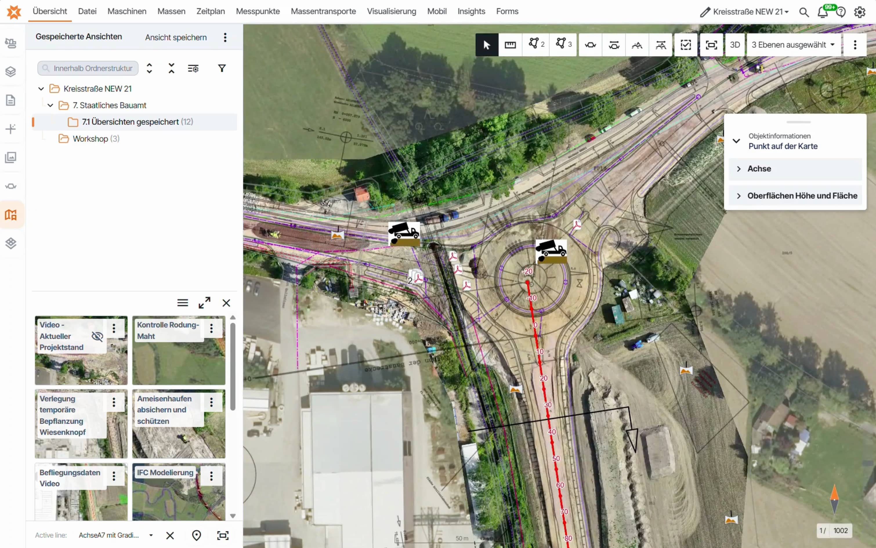
The way this collaborative approach works in practice becomes clear through its day-to-day use on site. Everyone starts from the same place: a shared, map-based interface. Every item has a location, making it easy to find again.
Georeferenced drawings and models. The foreman opens the relevant area on a tablet while standing on site and immediately sees the latest approved information. There is no longer any question as to whether the printed drawing in the site office is still current.
Digital site diaries. Records are created where the work is carried out and become available immediately, rather than being typed up later that evening. For the construction supervision team, this means being able to review what happened on site without first having to request the information.
Photographic documentation with location and timestamp. On a project involving layer-by-layer excavation under unexploded ordnance supervision, condition surveys of access roads and documentation requirements for material storage areas, this is not simply a matter of convenience. It protects both contracting parties.
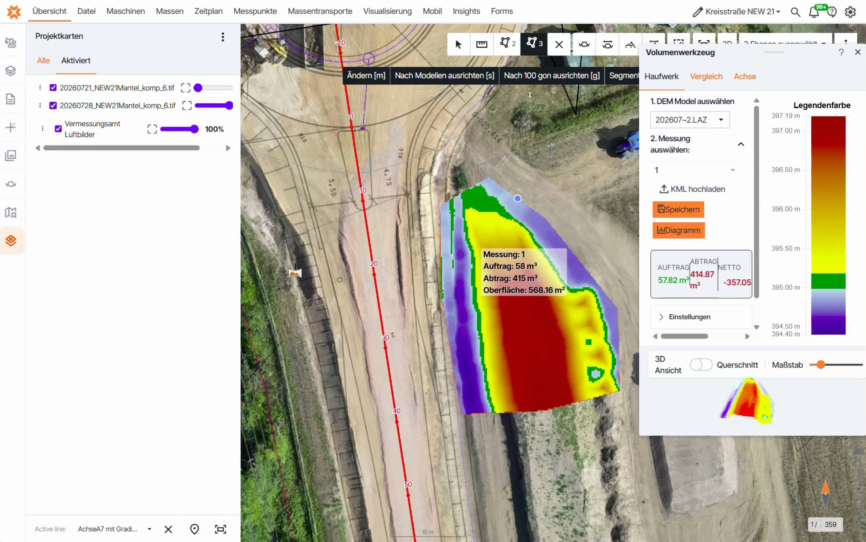
Drone surveys for quantity calculations. Regular flights provide orthophotos and an up-to-date terrain model. These can be used to calculate fill quantities and excavation volumes, assess progress on the embankment or floodwater retention area and compare actual conditions against the design model. Instead of relying on estimated interim figures, all parties can access the same measured status at the same time.
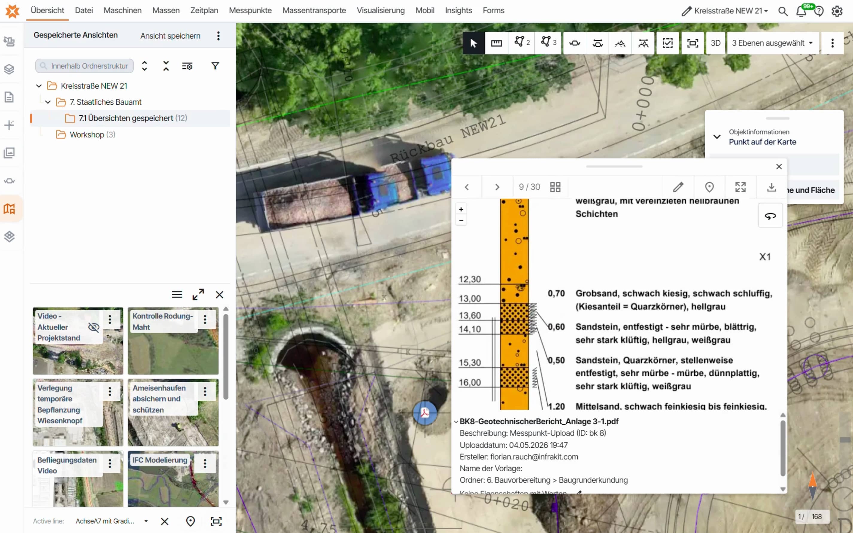
Integration of surveying workflows. Survey measurements and point data captured in the field are stored in the same environment as drawings, models and site documentation. Everyone therefore works within a consistent coordinate reference system and from the same dataset, without discussions about different versions of email attachments.
Filtering by date, construction section and keyword. In day-to-day use, this is often one of the most valuable capabilities. Questions such as, “What happened in this area during week X, and which photos, reports and survey records relate to it?” can be answered in seconds rather than hours. During payment assessment, variation reviews or the clarification of delays and disruptions, this can determine both the amount of effort required and whether an open question develops into a dispute.
Sometimes sustainability is an anthill
The importance of a shared data environment becomes particularly clear when something unexpected happens on site.
When the construction industry discusses sustainability, the conversation almost always centres on carbon emissions. Rightly so—and this is an area in which we are also working. On site, however, sustainability is often something much smaller and more tangible.
An anthill requiring protection was discovered at Mantel. Such a finding was not entirely unexpected: the works specification explicitly requires ant nests encountered during turf translocation to be excavated as deeply as possible and moved in their entirety. The project owner had therefore considered the issue from the outset.
In a conventional workflow, this could quickly trigger a lengthy chain of communication. The finding is reported, described over the phone, perhaps photographed and eventually inspected. Valuable time can pass before everyone has the same understanding of the situation. If additional costs are discussed later, the conversation may be based on recollection: Where exactly was the anthill? When was it first identified? How large was the affected area?
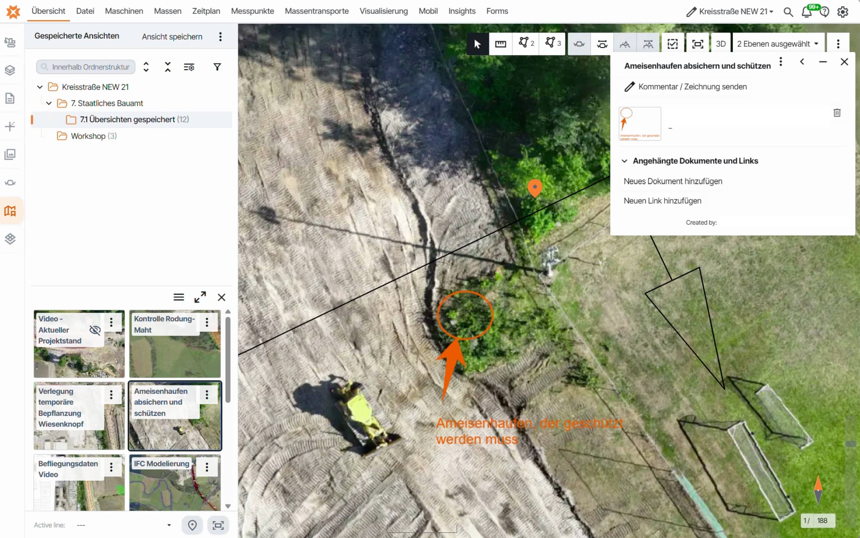
Here, the process was different. The finding was marked directly on the map and documented with a photograph, its precise location and the date. The information was immediately visible to the relevant parties: site management, construction supervision, environmental site supervision and the project owner.
This delivers three benefits at once:
- Environmental requirements are met without bringing the entire site to a standstill. It is clear where work must stop and where construction can continue.
- The contractor has a clear and traceable record of any additional work—not as leverage, but as a basis for an objective assessment.
- The project owner can subsequently demonstrate how the finding was handled. On a project involving amphibian guidance systems, turf translocation and protective fencing around sensitive habitats, this is far from a secondary concern.
An anthill illustrates the real meaning of transparency more effectively than any presentation slide. Transparency is not a means of control. It is the fastest route to a shared decision, and it protects both contracting parties.
The real value
What the anthill demonstrates on a small scale applies to the entire project: individual records combine to create a continuous picture of the construction site, closely reflecting what is actually happening and ensuring that everyone works from the same information. Less time spent searching, fewer follow-up questions and fewer coordination meetings whose outcomes can no longer be reconstructed later. Decisions are based on data rather than informal verbal updates.
The final as-built documentation will not become an additional task that has to be completed only after the road has opened to traffic. Instead, it is created as a natural by-product of well-structured daily work.
People make the difference
This brings us to the aspect of the project that we value most.
After several years in this market, we have reached a clear conclusion: public authorities do not digitalise projects. Companies do not digitalise projects. Individual people do.
It takes someone willing to add a section to the works specification even though no template exists. Someone on the other side of the table who does not immediately consider how the new requirement could be turned into a variation, but instead says, “Let’s try it.” A surveyor who does not treat their data as personal property, but as a resource for the entire project. A construction supervisor prepared to change established workflows. And a foreman who does not leave the tablet in the site office simply because “we managed without it before.”
This is uncomfortable, and it takes courage. The reason is structural: the effort is required today and in one specific area, while the benefits often emerge later and elsewhere—during payment assessment, variation negotiations, operations or the next project. Someone responsible only for their own part of the process may not immediately see the value that the change creates elsewhere.
That is precisely why change in construction needs pioneers: people who look beyond their own area of responsibility, recognise the benefits for the project as a whole and are still prepared to drive change forward. People willing to have a difficult conversation without expecting immediate recognition. People who take the first step even when no one requires them to.
We found exactly these kinds of people at the Amberg-Sulzbach State Building Authority. And we found them at Josef Rädlinger Unternehmensgruppe—on both sides. That is rare, and it is one of the main reasons this collaborative approach works in practice.
Why we are sharing this story
Because this project shows that it can be done—not on a flagship scheme with a special budget, but on a district road project in Bavaria, with potential unexploded ordnance, a floodplain, amphibian fencing and a programme that leaves no room for delay.
Our thanks go to everyone involved at the Amberg-Sulzbach State Building Authority and to the Josef Rädlinger Unternehmensgruppe team—not simply to the organisations, but to the people behind them.
If more people think and act this way, then in a few years we will no longer be discussing CDE requirements in tenders. Instead, we will be asking how we ever managed without them.
NEW 21 district road realignment near Mantel | District of Neustadt an der Waldnaab
Project owner: Amberg-Sulzbach State Building Authority | Contractor: Josef Rädlinger Unternehmensgruppe | CDE and construction delivery platform: Infrakit