Construction drone mapping and reality capture
Upload drone data from any source — orthophotos, point clouds, and volume calculations land on the same map where your field teams work and machines report progress.
Request a demo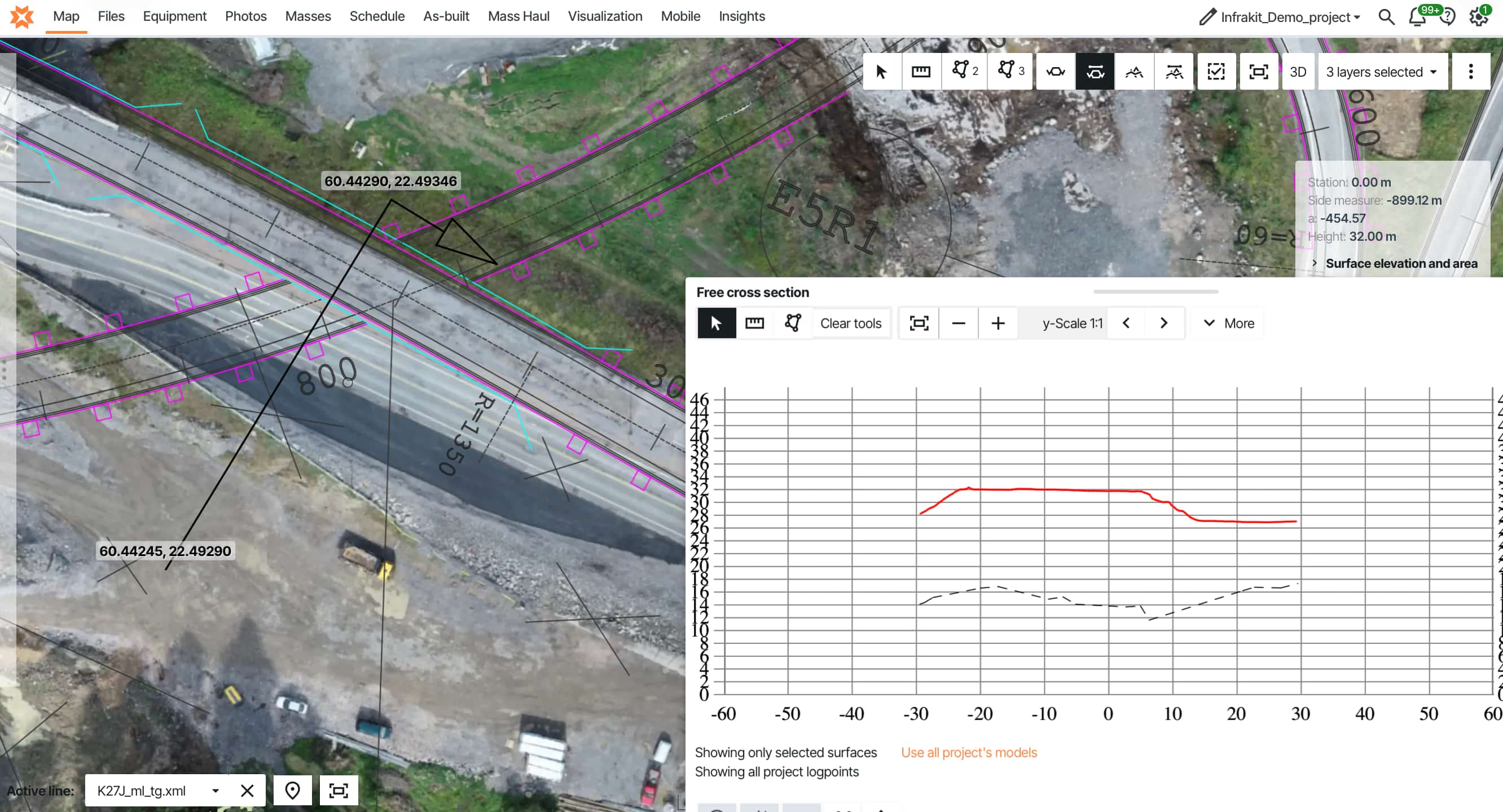
How drone mapping works as an integrated construction tool — not just a surveying method. Volume calculations that validate machine progress, orthophotos accessible to field teams in real time, and how infrastructure teams on 30km+ projects eliminated manual data correlation entirely.
Drone mapping for construction has become standard on infrastructure projects — capturing site data faster and more accurately than traditional surveying methods. Most contractors now use drones regularly.
But here's the thing: construction projects usually don't fail for mysterious reasons. Delays, cost overruns, safety problems — often stem from the same issue: teams don't know what's happening at the site unless they're physically there. For years, the only way to understand progress was through reports and walking the job site. That works, but it leaves gaps.
The challenge isn't getting aerial images — it's turning them into actionable information that integrates with construction workflows. Here's what typically happens: your drone service delivers the weekly survey. Data gets processed into orthophotos and point clouds. Your surveyor calculates earthwork volumes and uploads results to the project folder.
Field teams can't access those orthophotos on their tablets. Machine operators don't see how drone-measured volumes compare to their reported progress. When the project owner asks for earthwork status with photo verification, someone spends hours pulling drone files from one location, field photos from another, machine data from a third system — manually combining everything into a report.
The drone flight took two hours. Data correlation takes half a day. Every week. Infrakit's cloud platform puts drone data on the same map where field teams document work and machines report as-built conditions. Upload once, integrate automatically.
Let's look at how integrated drone mapping works for infrastructure projects — and why it's replaced traditional surveying methods on large-scale earthwork projects.
What is drone mapping for construction?
Drone mapping for construction captures aerial imagery with drones, processes that imagery into georeferenced outputs like orthophotos and point clouds, and uses those outputs for site documentation, volume calculations, and progress tracking on infrastructure projects.
The distinction from general aerial photography is precision and measurement capability. A construction drone captures overlapping images with GPS coordinates. Photogrammetry software processes those images into outputs where every pixel has a real-world location. You can measure distances, calculate volumes, and compare current conditions against design models — all from aerial data.
For infrastructure projects spanning kilometers, this changes the economics of surveying. A traditional total station survey of a 10-kilometer highway alignment might take surveyors a week. A drone captures the same alignment in hours. The resulting orthophotos and point clouds provide continuous coverage rather than spot measurements at control points.
Traditional land-based surveying also struggles with hard-to-reach or hazardous areas — steep embankments, unstable slopes, areas near active traffic. Drones access these sites safely and capture precise data without putting survey crews at risk. This matters particularly for highway projects, bridge inspections, and sites with challenging terrain.
The technology serves three primary functions: site documentation (orthophotos as a visual record), volume calculations (comparing point clouds to design grade), and progress verification (sequential flights create a timeline of construction advancement). The workflow starts with flight planning and an automated drone path capturing images with 70-80% overlap. Photogrammetry software processes those images into orthophotos and a point cloud representing the terrain surface.
The difference between drone mapping as a one-time survey and drone mapping as an integrated construction tool is what happens after the flight.
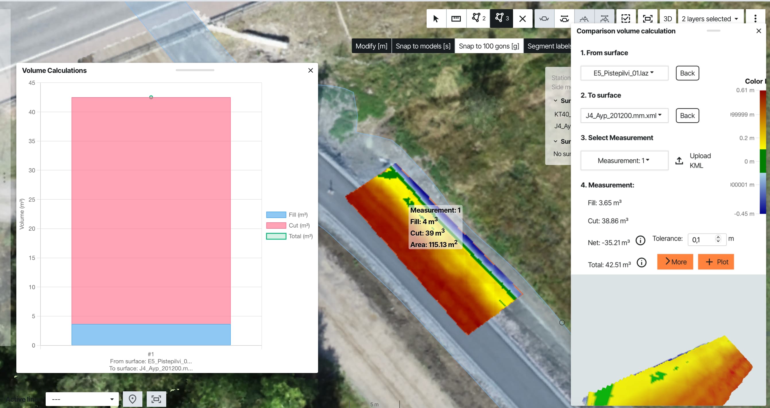
Volume calculations and earthwork tracking
You need to know three things every week: how much earth actually moved, whether you're on grade, and if stockpiled quantities match what you're paying for. Drone mapping answers all three.
Traditional approach: your surveyor walks control points with a total station, measures spot elevations, interpolates between them. Good enough for rough tracking, not precise enough when material costs €20/m³ and you're moving 180,000 m³ total.
Drone mapping captures point clouds of the entire surface. Instead of "we're about 60% complete on earthwork," you get: "Station 8+200 to 9+450 needs 2,400 m³ additional cut. Station 12+800 to 13+950 requires 1,850 m³ fill to reach design grade." You know exactly where to send equipment tomorrow.
Your aggregate supplier invoices 8,000 m³. Drone measurement shows actual quantity: 7,200 m³ — 800 m³ short. That's €12,000 to €20,000 depending on material type. This happens more often than suppliers admit. Drone measurements give you verification before you approve payment.
Your dozer operator reported 900 m³. Drone shows 840 m³. Close enough to validate the work. If the numbers diverged significantly — operator reports 1,500 m³ but drone shows 600 m³ — you'd investigate before the next progress payment. Sequential drone surveys create a measurement timeline — not just where you are now, but verified proof of how you got there.
Useful for progress billing. Essential when the owner questions reported quantities. Identify delays early — earthwork falling behind at station 14+000 becomes visible before it impacts paving schedules.
Pull up the project map without current drone data: satellite imagery from 2021, stockpiles showing as empty fields, existing access roads not on the map. Updated drone orthophotos every week or two means you're designing from current reality.
"Once I started actively using our drone, I cannot imagine why I wouldn't use it anymore. Instantaneously the drone became irreplaceable as it provides new tools for site documentation and monitoring." — Tero Maijala, Destia E18 Turku ring road.
One platform for drone data, field reports, and machine control
You've got drone orthophotos, machine as-built data, and field photos. All useful — if people can actually access them.
Upload a fresh orthophoto once and current conditions appear on every device instantly — haul routes, equipment positions, excavation edges, all visible and important for safety.
When design changes happen, one platform distributes updates everywhere simultaneously. Machines, tablets, office — all updated within minutes. No missed updates, no rework from outdated models.
For long projects, accessible history matters. Toggle any month, see orthophotos, machine tracks, field photos from that period. Essential for warranty claims years later.
Drones also improve safety on infrastructure projects. Instead of sending survey crews onto unstable embankments or near active traffic lanes, drones inspect these hazardous areas remotely. Survey steep slopes without workers climbing them. Inspect bridge underpasses without workers accessing areas near heavy equipment or traffic. The aerial perspective keeps personnel out of harm's way while still capturing the data needed for design and quality verification.
They work better together. Station 18+000 shows volume shortage — 400 m³ less cut than expected. The point cloud shows it. Orthophoto reveals why: rock outcrop not in geotechnical reports. The 3D model shows the extent and impact on adjacent areas. Three outputs, complete picture in minutes. Traditional: survey shows problem, schedule site visit to understand why. Integrated platforms generate all three automatically from the same flight.
See how Infrakit Office manages all project data in one place →
Stop managing drone data. Start using it.
Upload orthophotos, point clouds, and volume calculations from any drone source. Infrakit puts them on the same map where machines report as-built and field crews document work — automatically integrated.
"Once I started actively using our drone at our site, I cannot imagine why I wouldn't use it anymore. Instantaneously the drone became irreplaceable as it provides new tools for site documentation and monitoring."
Tero Maijala Site Manager · Destia E18 Turku Ring Road (€39M, 10km)Orthophotos, point clouds, and 3D mapping deliverables
Defects appear in the asphalt two years later. Was it bad paving or a problem with the base layer underneath? Without photos from installation, you're guessing. Digging up the road to check costs tens of thousands.
Pull up the orthophoto from installation week instead. See exactly what the base layer looked like before paving. Problem solved without excavation. For buried work — drainage, utilities, base layers — orthophotos become your only proof once backfill happens.
"Before we had metres and metres of quality control folders in the office, now all the relevant data is in one place." — Heino Karjalainen, Destia.
Point clouds catch problems you can't see. The design requires 2% slope for drainage. Looks fine after grading. Point cloud measurements show the slope varies between 1.2% and 2.8%. Water will pool in the low spots. Fix it now: two hours. Fix it after paving: tear out and rebuild the section.
Compare this week's point cloud to last week's. The area that should be stable dropped 3cm. Weak ground underneath. Better to discover it now than after structures are in place.
Drone surveys with RTK/PPK correction typically achieve 1–2% volume accuracy on large earthwork areas — compared to 5–10% uncertainty with manual spot measurements. The accuracy difference becomes significant when material costs €15–25 per cubic meter.
3D models save coordination time. The design team needs to review the ramps. Contractor checking clearances. Utility company verifying conflicts. Everyone used to drive to the site and walk around pointing at stakes.
Share a 3D model instead. Everyone reviews from their office. Questions get answered remotely. Site visit only if there's actual conflict. Reality capture using detailed aerial images helps teams build accurate 3D models of existing conditions — identifying conflicts before work starts, not halfway through the job.
"We avoid a lot of mistakes every day by being confident that the machines have the right basis. Drone photography provide great benefits in terms of time and money."
Terje Glad BIM Manager · Veidekke E6 Arnkvern-OlumDownload: 10 Steps to Deliver Infrastructure Projects On Time & On Budget
Learn from teams on the Tampere tram, Norway's E6 highway, and Austria's A9 motorway — including how they use drone mapping as part of integrated construction workflows.
Drone mapping use cases from infrastructure projects
Monthly drone flights integrated with machine control data, weekly calibration tracking, and real-time mass haul monitoring. Instead of managing five different portals, the team managed everything through one platform.
Read more about PEAB's E6 project →"We fly once a month and make new orthophotos. Instead of going through five different portals, it now sticks with one. Overall, this provides much more efficient machine control."
Eirik Frimannslund Survey Manager · PEABOrthophotos became the foundation for planning, progress tracking, and coordination across the construction team. Machine operators could see their location on current drone imagery. Used heavily in meetings to quickly explain, clarify, and solve problems.
"Orthophotos are absolutely necessary in the background for the project. It is possible to quickly explain, clarify, and solve problems. Without Infrakit, the alternative would have been physical inspection at the site."
Trond Ivar Nordal Survey Leader · NCC Bergen Light RailSix machine control brands unified with regular drone mapping. Weekly filming gave the team an ongoing view of construction progress used heavily in meetings and planning. Quarterly orthophotos provided a documented record of site conditions over time — making it possible to look back at how the project developed from the start.
"Now we have updated drone images and can for example look back at what it looked like in 2018. It is an incredibly important tool. Infrakit has been very responsive to our wishes, and we have had many improvements implemented. It is a very good tool."
Jan Steinar Stein Survey Manager · Veidekke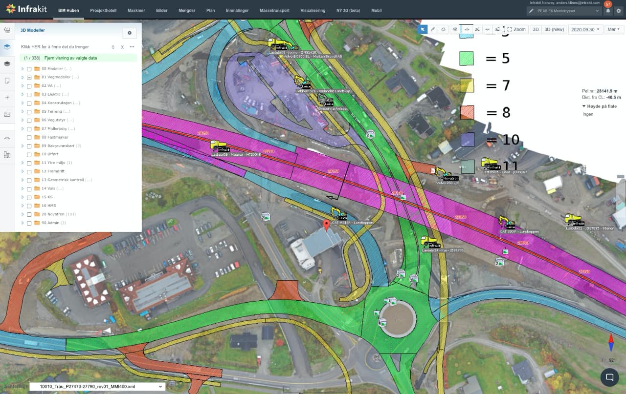
Infrastructure teams that get value from drone mapping follow similar patterns: weekly or biweekly flights keep basemaps current. Field crews access orthophotos on tablets. Volume calculations validate machine-reported progress. Project owners check status themselves — no manual reports needed.
Time saved: 15–20 hours weekly per surveyor. Not downloading files from multiple systems. Not manually correlating data. Time redirected to actual surveying and quality control.
What worked: regular flights, platform integration, automated documentation. What didn't: one-time surveys, standalone data, manual correlation across systems. The difference: drone mapping delivers value when it integrates with construction workflows — not when it creates another set of files to manage.
Your surveyor spends hours downloading files, converting formats, correlating data from different systems. That's an integration problem, not a drone problem.
Infrakit puts orthophotos, volumes, and point clouds on the same map where machines report as-built and field crews document work. Upload once. Processing happens automatically. Everyone sees current data.
Technology itself doesn't solve bad planning — it gives better information. What matters is how people use it. Drones and reality capture won't replace experience, but they support better decisions. When everyone looks at the same data, conversations become more objective.
YIT's 32km highway and Destia's 30km rail project run this daily. The question isn't whether drone mapping works — it's whether your data integrates with construction or creates another system to manage. Request a demo to see how it works for infrastructure projects like yours →
Frequently asked questions | Can we use our existing drone service provider? What's the difference between drone mapping for construction vs. traditional surveying? How often should we fly infrastructure projects? Do drone orthophotos work in the field? What accuracy can we expect for volume calculations? How long does drone data processing take? Can project owners access drone data directly? |