Managing multiple machine control solutions: One platform for all brands
When quality documentation is created at the same time as construction, rather than after, you eliminate delays that cause rework, disputes and costly handover surprises.
Book a demo
How GPS machine control integration works, why managing multiple brands creates friction, and how infrastructure teams are saving 20+ hours per week by switching to a single unified platform.
Machine control technology is transforming infrastructure construction—from excavators that automatically follow design grades to dozers guided by 3D models with centimeter precision.
But it doesn't always go as planned. Here's a common situation. Design revision 2.4 just came through—the highway alignment shifted 2 meters to avoid a utility conflict. Your surveyor needs to push updated models to the machines.
Five manufacturer portals. Five uploads. Five different file format requirements. Forty-five minutes to upload. Then another hour checking which machines actually received the updates. Two excavators timed out. One dozer isn't syncing. Email the operator to restart his system.
Tomorrow brings another revision. Next week, another. The portal juggling never stops.
What if you could upload once and distribute to every machine automatically, regardless of brand? One platform connecting all your equipment. One upload. Automatic distribution. Complete fleet visibility.
What are 3D machine control systems?
GPS receivers on excavators and dozers know their exact position. A 3D design model is loaded. The cab display shows real-time guidance: "Bucket is 23cm above design elevation" or "Blade is 4cm below target." On automated systems, hydraulics adjust automatically to match design elevations.
Before GPS, operators relied on grade stakes—wooden stakes every 15–20 meters showing cut or fill depths. Surveyors spent days staking sites. Stakes got knocked over. Accuracy depended on operator skill.
GPS changed this. The machine knows where it is to centimeter accuracy. Load the design model once. Continuous real-time guidance across the entire work area. No stakes needed. Less experienced operators achieve results that previously required years of skill.
The technology works. The challenge? Managing it when your project has multiple equipment brands working simultaneously.
 GPS-guided machines work to centimeter accuracy across the entire site.
From point checks to continuous precision
The defining advantage of machine control isn't simply higher accuracy—it's process certainty. By integrating GPS positioning, inertial measurement units, and 3D digital design models, these systems place design intent directly inside the cab.
Operators no longer work toward abstract targets defined by stakes. They see real-time cut and fill values, surface profiles, and machine position relative to the design model. Every movement is guided, measured, and continuously corrected.
The shift from point-based verification to continuous control changes everything. Manual methods verify grades at discrete locations—every 15–20 meters if you're lucky. GPS machine control evaluates the entire working surface in real time. Over-excavation and under-cutting are identified instantly, not after the fact. Material waste decreases. Haul cycles reduce. Fuel consumption drops.
More importantly, operators gain confidence to work faster because the system continuously validates their work. Fewer passes. Shorter schedules. Predictable outcomes.
Productivity extends beyond the machine. With fewer survey checks required, ground personnel exposure decreases and safety improves. Operators stay in the cab. Survey teams focus on higher-value tasks—design verification, as-built documentation, quality control—instead of checking every cut.
When machine control connects to surveying equipment, drone data, and design systems, contractors build a connected digital workflow from site layout through final surface verification. This is where managing multiple manufacturer portals becomes the limiting factor. The technology delivers continuous precision. The fragmented portal workflow breaks the data flow. See how Infrakit unifies all machine control brands
The cost of managing multiple machine control systems
The inefficiency compounds in ways that aren't obvious until you track it. What looks like "just part of the job" adds up to measurable costs.
Version control breaks down when you're checking six dashboards instead of one. On a 12-hour shift with multiple design updates, something gets missed. A dozer works from an outdated model for 90 minutes before anyone notices. That section needs rework.
File format conversion introduces risk. A curve exports from LandXML to Topcon's .tp3 format—the geometry shifts slightly. The same curve converts to Leica's .dxf format—another small shift. Small errors accumulate across multiple conversions.
"We were using up to five different platforms just to push models and pull as-built data. It was messy and cost us hours every week."
Kristen Petillon Head of Machine Control · AF GruppenOn a two-year infrastructure project with three surveyors, that's 15–20 hours weekly per person on portal management — $187,000–$312,000 annually in overhead costs, before accounting for rework from the version control and conversion errors that inevitably slip through.
This problem scales with project complexity. The larger the project, the more equipment brands, the more design changes—the worse it gets. Teams on major infrastructure projects like the Tampere tram, Norway's E6 highway, and Austria's A9 motorway have found better approaches. See their strategies: 10 Steps to Deliver Infrastructure Projects On Time & On Budget

Connect all machine control brands in one platform

Upload once, distribute to every machine automatically

Deploy your site people to do high-quality measurements with any RTK GNSS antenna
How does GPS machine control integration work?
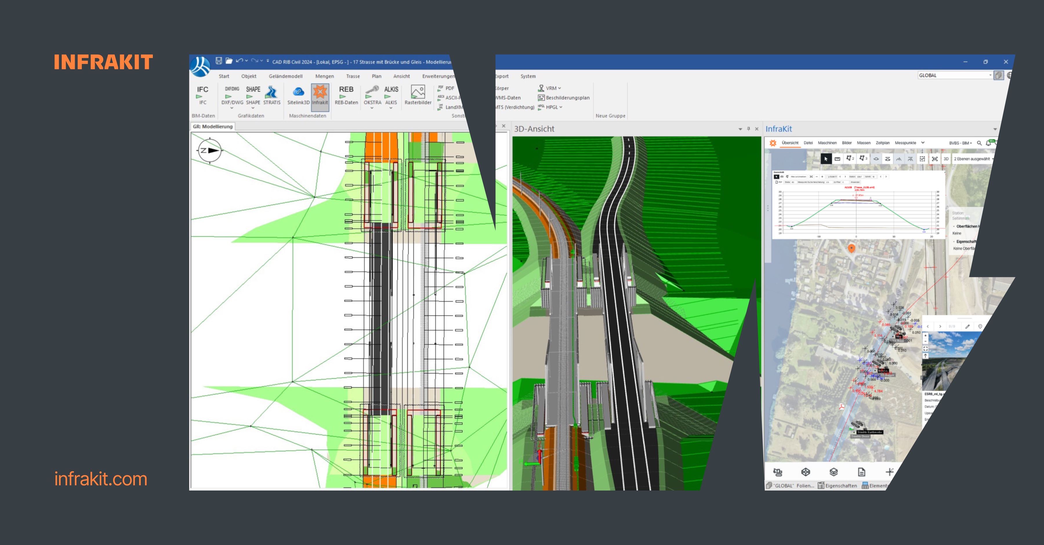
Integration platforms connect to manufacturer clouds through APIs. When you upload a 3D model to the platform, it automatically converts to each manufacturer's format and pushes to their portal via API—Trimble WorksManager/WorksOS, Topcon Sitelink 2, Leica ConX, Novatron Xsite.
One upload. Automatic distribution. Single dashboard showing which machines have which versions across all brands.
File conversion happens automatically. Export one LandXML file from your design software. The platform converts to Trimble .cal, Topcon .tp3, Leica .xml, Cat formats, and others as needed. No manual conversions.
As-built data flows back the same way. Machines generate as-built points that sync to manufacturer clouds. The integration platform polls via API, pulls the data, and standardizes it to common coordinates, unified point coding, and consistent timestamps. The points appear on your project map in real-time regardless of which equipment generated them.
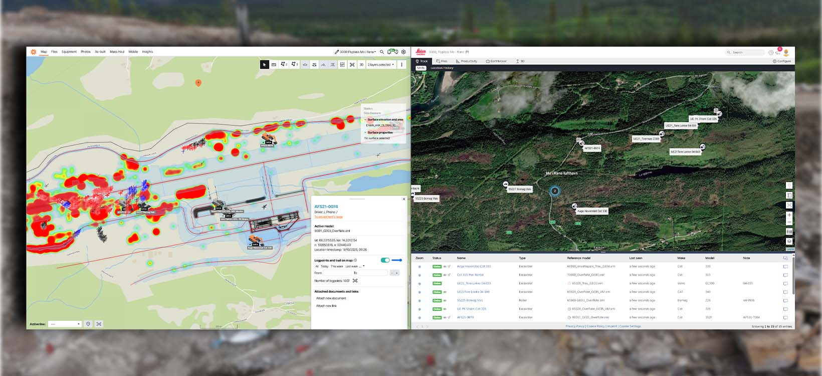
Equipment visibility across brands. One dashboard shows entire fleet status:
- >Trimble dozer #4: Online, Model v2.4, last active 14 minutes ago
- >Leica excavator #2: Online, Model v2.4, working at station 18+340
- >Topcon grader #1: Offline, Model v2.3 (needs update)
"Before, we used several programs with different portals. This meant that we had to post models several times. On Infrakit they are collected."
Eirik Frimannslund Survey Manager · PEABHow to manage multiple machine control systems?
Infrastructure projects mix equipment brands by necessity. You own Trimble-equipped excavators. The earthworks sub brings Leica-equipped excavators. The grading sub prefers Topcon. You rent a Novatron-equipped excavator for a specific phase. Integration platforms handle this reality.
Supported systems include Trimble (WorksManager), Topcon (Sitelink 2), Leica (ConX), Caterpillar (VisionLink), Komatsu SmartConstruction, Unicontrol, Makin, Novatron, Digpilot, and regional systems. The point is flexibility—use whatever equipment makes sense.
Beyond model distribution, the platform tracks machine calibration, equipment status, and work activity. PEAB's E6 project integrated weekly calibration monitoring—the system flags when accuracy drifts outside requirements. Catch calibration problems before they affect work quality.
- >Equipment comes and goes — add a rental excavator and it connects automatically
- >Weekly calibration monitoring flags when accuracy drifts outside requirements
- >Design files, survey points, drone photos all connected to the same project map
- >Setup typically takes days, not months — migrate gradually during natural project phases
- >Operators keep using familiar in-cab displays — the difference is entirely on the backend
 One dashboard. Every brand. Real-time model versions and fleet status at a glance.
Infrastructure teams saving 20+ hours per week
Mixed fleet across multiple subcontractors and equipment suppliers — all managed from a single dashboard without forcing every supplier onto the same hardware.
Read more about AF Gruppen's E39 project →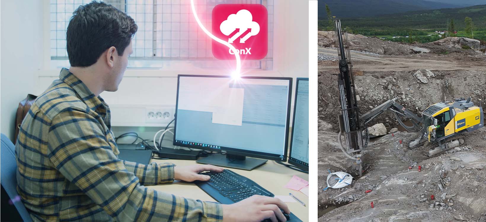 AF Gruppen's E39 motorway — 19km of mixed-fleet machine control, one dashboard.
Four-lane, 110 km/h motorway replacing an 80 km/h road. Six machine control brands on a single site — all unified under one platform.
"We get the measurements and log-points from the excavators, straight into Infrakit, without the need of any other software."
Jan Steinar Stein Surveying Leader · VeidekkeNo more downloading from six portals or manually consolidating six file formats.
Turnkey contract with frequent design changes requiring efficient distribution across mixed brands.
"Instead of going through five different portals, it now sticks with one. Overall, this provides much more efficient machine control."
Eirik Frimannslund Survey Manager · PEABCommon patterns across projects: 15–20 hours per week per surveyor freed from portal management. Time redirected to actual surveying, quality control, and project coordination instead of converting file formats.
Model updates take minutes instead of hours. Version control becomes visible instead of guesswork. As-built data arrives standardized instead of requiring manual reconciliation from multiple sources.
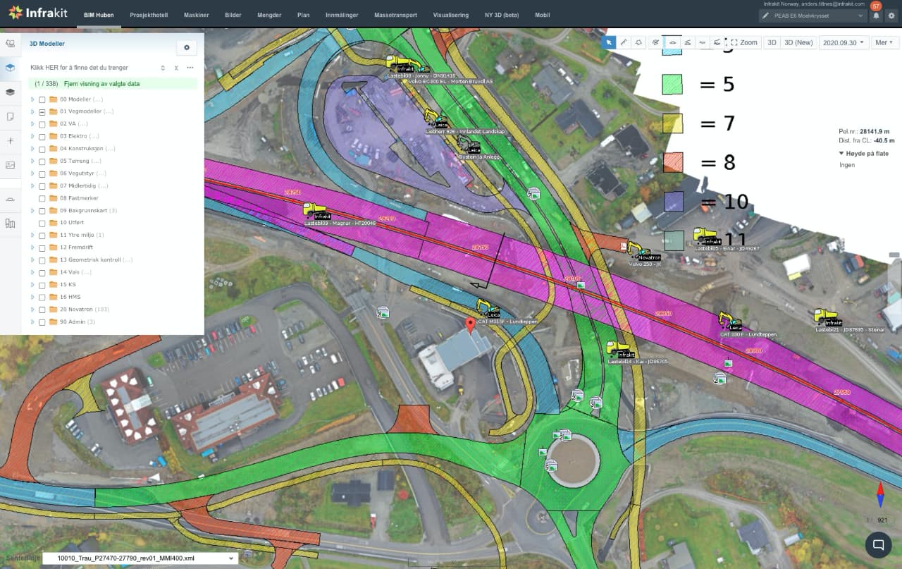 One platform connecting Trimble, Topcon, Leica, Novatron and more — real-time fleet visibility across all brands.
What doesn't work: Manual portal management doesn't scale—the burden compounds as project complexity increases. Standardizing on one manufacturer limits equipment flexibility with rentals and subcontractors. Manual file conversion is error-prone and time-consuming. Spreadsheet tracking breaks down with 20+ machines.
The pattern is clear: Infrastructure projects with mixed fleets benefit from unified machine control platforms. The alternative—juggling multiple manufacturer portals—works for small projects with one or two equipment brands. It collapses under the complexity of large highways with dozens of machines from six different manufacturers.
Certainty is the competitive advantage
Your machine control systems work extraordinarily well. Excavators hit grade to the centimeter. Dozers follow 3D models precisely. The technology isn't the problem.
The problem is everything around it.
Your surveyor uploads the same model file to five different portals. Checks six dashboards to confirm which machines synced. Downloads as-built data from six different clouds. Converts formats. Reconciles coordinates. Twenty hours a week—not surveying, just managing portals.
There's a better way.
Infrakit puts everything on one map. Not just machine control—everything. Design models, as-built points, machine locations, photos, drone imagery, quality measurements. All connected to the same real-time map view.
Upload your design model once. It distributes automatically to every brand—Trimble, Topcon, Leica, Cat—through API connections. As-built data flows back in real-time, already standardized. Version control is visible at a glance across your entire fleet.
The impact: 15-20 hours per week recovered per surveyor. On a two-year project with three surveyors, that's $187,000–$312,000 in overhead eliminated—before accounting for reduced rework from version control problems.
This is how infrastructure projects scale. Not by managing more portals. By putting everything on one map where everyone can see what's actually happening.
Ready to see how it works for your projects? We'd be happy to show you how Infrakit connects all your machine control brands—Trimble, Topcon, Leica, Cat, and more—in one platform. Book a demo to talk about your specific setup.
Frequently asked questions | Can we switch to a map-first platform mid-project? Do machine operators need retraining? How long does integration setup take? What about data security and compliance with owner requirements? What size projects benefit most from map-first platforms? What happens when manufacturers update their cloud systems? |